File:Troy Skyline looking east fr Coolidge Hwy and Big Beaver Rd.jpg

Size of this preview: 800 × 315 pixels. Other resolutions: 320 × 126 pixels | 640 × 252 pixels | 1,024 × 403 pixels | 1,280 × 503 pixels | 4,607 × 1,812 pixels.
Original file (4,607 × 1,812 pixels, file size: 6.84 MB, MIME type: image/jpeg)
Captions
Captions
Troy Skyline
Summary edit
| Description |
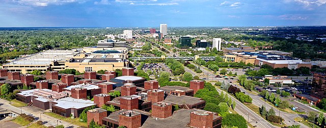
English: Skyline of the city of Troy looking east from the the intersection of Coolidge Hwy and Big Beaver Rd (16 Mile Rd) |
| Date | |
| Source | Own work |
| Author | Lrgjr72 |
| Camera location | | View this and other nearby images on: OpenStreetMap |
|---|
Taken with a DJI drone summer 2021
Licensing edit
I, the copyright holder of this work, hereby publish it under the following license:
This file is licensed under the Creative Commons Attribution-Share Alike 4.0 International license.
- You are free:
- to share – to copy, distribute and transmit the work
- to remix – to adapt the work
- Under the following conditions:
- attribution – You must give appropriate credit, provide a link to the license, and indicate if changes were made. You may do so in any reasonable manner, but not in any way that suggests the licensor endorses you or your use.
- share alike – If you remix, transform, or build upon the material, you must distribute your contributions under the same or compatible license as the original.
File history
Click on a date/time to view the file as it appeared at that time.
| Date/Time | Thumbnail | Dimensions | User | Comment | |
|---|---|---|---|---|---|
| current | 22:02, 30 December 2022 | 4,607 × 1,812 (6.84 MB) | Lrgjr72 (talk | contribs) | Uploaded own work with UploadWizard |
You cannot overwrite this file.
File usage on Commons
There are no pages that use this file.
File usage on other wikis
The following other wikis use this file:
- Usage on en.wikipedia.org
- Usage on zh.wikipedia.org