File:Tucker's & Morgan's Islands, Bermuda.jpg

Size of this preview: 800 × 358 pixels. Other resolutions: 320 × 143 pixels | 640 × 286 pixels | 1,024 × 458 pixels | 1,925 × 861 pixels.
Original file (1,925 × 861 pixels, file size: 308 KB, MIME type: image/jpeg)
Captions
Captions
Add a one-line explanation of what this file represents
Summary
edit
| Description |
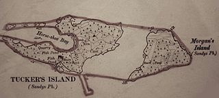
English: Tucker's & Morgan's Islands, Bermuda, which were joined together and made contiguous with the Main Island of Bermuda in the 1940s in order to construct the US Naval Operating Base. |
| Date | |
| Source | Original |
| Author | Ordnance Survey |
| Camera location | | View this and other nearby images on: OpenStreetMap |
|---|
- Other information
English: Created by Lieutenant A.J. Savage, Royal Engineers
This work created by the United Kingdom Government is in the public domain.
This is because it is one of the following:
HMSO has declared that the expiry of Crown Copyrights applies worldwide (ref: HMSO Email Reply)
|
 |
File history
Click on a date/time to view the file as it appeared at that time.
| Date/Time | Thumbnail | Dimensions | User | Comment | |
|---|---|---|---|---|---|
| current | 15:51, 21 November 2016 | | 1,925 × 861 (308 KB) | Aodhdubh (talk | contribs) | {{subst:Upload marker added by en.wp UW}} {{Information |Description = {{en|Tucker's & Morgan's Islands, Bermuda, which were joined together and made contiguous with the Main Island of Bermuda in the 1940s in order to construct the US [... |
You cannot overwrite this file.
File usage on Commons
There are no pages that use this file.
File usage on other wikis
The following other wikis use this file:
- Usage on en.wikipedia.org