File:Tukano Languages.svg

Size of this PNG preview of this SVG file: 800 × 412 pixels. Other resolutions: 320 × 165 pixels | 640 × 330 pixels | 1,024 × 528 pixels | 1,280 × 660 pixels | 2,560 × 1,320 pixels | 1,940 × 1,000 pixels.
Original file (SVG file, nominally 1,940 × 1,000 pixels, file size: 469 KB)
Captions
Captions
Add a one-line explanation of what this file represents
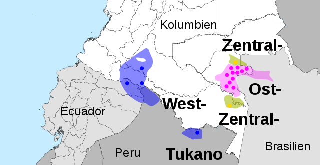
| Description | East Tukano (pink), Central Tukano (yellow) and West Tukano (blue). Spots indicate actual locations of different tukano languages, shadowed area intended extension before 20th century. |
| Date | (UTC) |
| Source | |
| Author |
|

|
This SVG file contains embedded text that can be translated into your language, using any capable SVG editor, text editor or the SVG Translate tool. For more information see: About translating SVG files. |
| This is a retouched picture, which means that it has been digitally altered from its original version. Modifications: SVG-File made, colors with more contrast. The original can be viewed here: Tukano Languages.png:
|
I, the copyright holder of this work, hereby publish it under the following license:
| I, the copyright holder of this work, release this work into the public domain. This applies worldwide. In some countries this may not be legally possible; if so: I grant anyone the right to use this work for any purpose, without any conditions, unless such conditions are required by law. |
Original upload log
edit
This image is a derivative work of the following images:
- File:Tukano_Languages.png licensed with PD-self
- 2009-11-15T13:48:40Z Davius 392x416 (29827 Bytes) {{Information |Description={{en|1={{Information |Description={{en|1=Proper Arawak Languages (Maipurean) (blue), Arawan Languages (green), Wahiboan languages (violet). Documented locations languages at present are signaled by
Uploaded with derivativeFX
File history
Click on a date/time to view the file as it appeared at that time.
| Date/Time | Thumbnail | Dimensions | User | Comment | |
|---|---|---|---|---|---|
| current | 04:04, 25 February 2016 | | 1,940 × 1,000 (469 KB) | Huhsunqu (talk | contribs) | Imagen más corta (Panamá y Venezuela?), arreglo en la extensión del Secoya en Perú |
| 20:38, 15 January 2010 |  | 1,940 × 2,009 (652 KB) | Milenioscuro (talk | contribs) | without cities of Colombia | |
| 23:16, 19 December 2009 |  | 1,940 × 2,009 (1.55 MB) | Bobi211 (talk | contribs) | schwarzer balken gelöscht | |
| 22:37, 17 December 2009 |  | 1,940 × 2,009 (1.55 MB) | Bobi211 (talk | contribs) | completely vectorised | |
| 20:48, 14 December 2009 |  | 392 × 416 (72 KB) | Bobi211 (talk | contribs) | {{Information |Description={{en|1=East Tukano (yellow), Central Tukano (red) and West Tukano (blue). Spots indicate actual locations of different tukano languages, shadowed area intended extension before 20th century. }} |Source=*[[:File:Tukano_Languages. |
You cannot overwrite this file.
File usage on Commons
The following 2 pages use this file:
File usage on other wikis
The following other wikis use this file:
- Usage on ca.wikipedia.org
- Usage on de.wikipedia.org
- Usage on fi.wikipedia.org
- Usage on hr.wikipedia.org
- Usage on sh.wikipedia.org