File:Tunguska-Map-fr.svg

Size of this PNG preview of this SVG file: 800 × 409 pixels. Other resolutions: 320 × 164 pixels | 640 × 328 pixels | 1,024 × 524 pixels | 1,280 × 655 pixels | 2,560 × 1,310 pixels | 977 × 500 pixels.
Original file (SVG file, nominally 977 × 500 pixels, file size: 235 KB)
Captions
Captions
Add a one-line explanation of what this file represents
Summary edit
| Description |
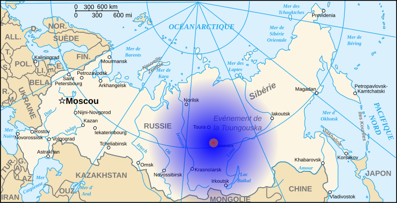
Français : Situation et zones d'impact de la météorite de la Toungouska.
Zone 1 (R=20 km) : forêt détruite (rouge) Zone 2 (R=100 km) : dégâts, brûlures, morts d'animaux (orange) Zone 3 (R=1500 km) : bruit de l'explosion (dégradé bleu) |
| Date | |
| Source | travail personnel (own work) à partir de Image:Map of Russia-fr.svg |
| Author | Denys (fr) ; historicair |
This W3C-unspecified vector image was created with Inkscape .

|
Ce fichier SVG contient du texte encapsulé pouvant facilement être traduit dans votre langue en utilisant n'importe quel éditeur de fichier SVG ou de texte, ou par l'outil de traduction de fichiers SVG. Pour plus d'informations, voir : A propos de la traduction des fichiers SVG. |
Licensing edit
I, the copyright holder of this work, hereby publish it under the following licenses:

|
Permission is granted to copy, distribute and/or modify this document under the terms of the GNU Free Documentation License, Version 1.2 or any later version published by the Free Software Foundation; with no Invariant Sections, no Front-Cover Texts, and no Back-Cover Texts. A copy of the license is included in the section entitled GNU Free Documentation License. |
This file is licensed under the Creative Commons Attribution 3.0 Unported license.
- You are free:
- to share – to copy, distribute and transmit the work
- to remix – to adapt the work
- Under the following conditions:
- attribution – You must give appropriate credit, provide a link to the license, and indicate if changes were made. You may do so in any reasonable manner, but not in any way that suggests the licensor endorses you or your use.
You may select the license of your choice.
File history
Click on a date/time to view the file as it appeared at that time.
| Date/Time | Thumbnail | Dimensions | User | Comment | |
|---|---|---|---|---|---|
| current | 08:31, 1 July 2008 | | 977 × 500 (235 KB) | Denys (talk | contribs) | {{Information |Description={{fr|1=Situation et zones d'impact de la météorite de la Toungaska. Zone 1 (R=20 km) : forêt détruite (rouge) Zone 2 (R=100 km) : dégâts, brûlures, morts d'animaux (orange) Zone 3 (R=1500 km) : bruit de l'explosion (dégr |
You cannot overwrite this file.
File usage on Commons
The following 2 pages use this file:
File usage on other wikis
The following other wikis use this file:
- Usage on az.wikipedia.org
- Usage on bg.wikipedia.org
- Usage on ca.wikipedia.org
- Usage on en.wikipedia.org
- Usage on eu.wikipedia.org
- Usage on fr.wikipedia.org
- Événement de la Toungouska
- Discussion:Événement de la Toungouska
- Utilisateur:Denys/Schemas
- Utilisateur:Andrej Boris Collinsson/Images Sibérie 2
- Wikipédia:Le Bistro/30 juin 2016
- Wikipédia:Le Bistro/Galerie/2016
- Wikipédia:Le Bistro/Galerie/Juin
- Wikipédia:Statistiques des anecdotes de la page d'accueil/Visibilité des anecdotes (2020)
- Discussion:Événement de la Toungouska/LSV 17672
- Wikipédia:Statistiques des anecdotes de la page d'accueil/Visibilité des anecdotes (2020)/2020 02
- Projet:Aide et accueil/Twitter/Tweets/archives/février 2020
- Wikipédia:Le saviez-vous ?/Archives/2020
- Usage on ga.wikipedia.org
- Usage on he.wikipedia.org
- Usage on hr.wikipedia.org
- Usage on hu.wikipedia.org
- Usage on hy.wikipedia.org
- Usage on it.wikipedia.org
- Usage on it.wikiquote.org
- Usage on ky.wikipedia.org
- Usage on no.wikipedia.org
- Usage on oc.wikipedia.org
- Usage on pl.wikipedia.org
- Usage on ro.wikipedia.org
- Usage on sr.wikipedia.org
- Usage on ta.wikipedia.org
- Usage on tr.wikipedia.org
- Usage on vec.wikipedia.org
- Usage on www.wikidata.org