File:Turcici Imperii Imago - btv1b59622100 (1 of 2).jpg

Size of this preview: 685 × 600 pixels. Other resolutions: 274 × 240 pixels | 548 × 480 pixels | 878 × 768 pixels | 1,170 × 1,024 pixels | 2,340 × 2,048 pixels | 5,917 × 5,179 pixels.
Original file (5,917 × 5,179 pixels, file size: 5.61 MB, MIME type: image/jpeg)
Captions
Captions
Add a one-line explanation of what this file represents
Summary
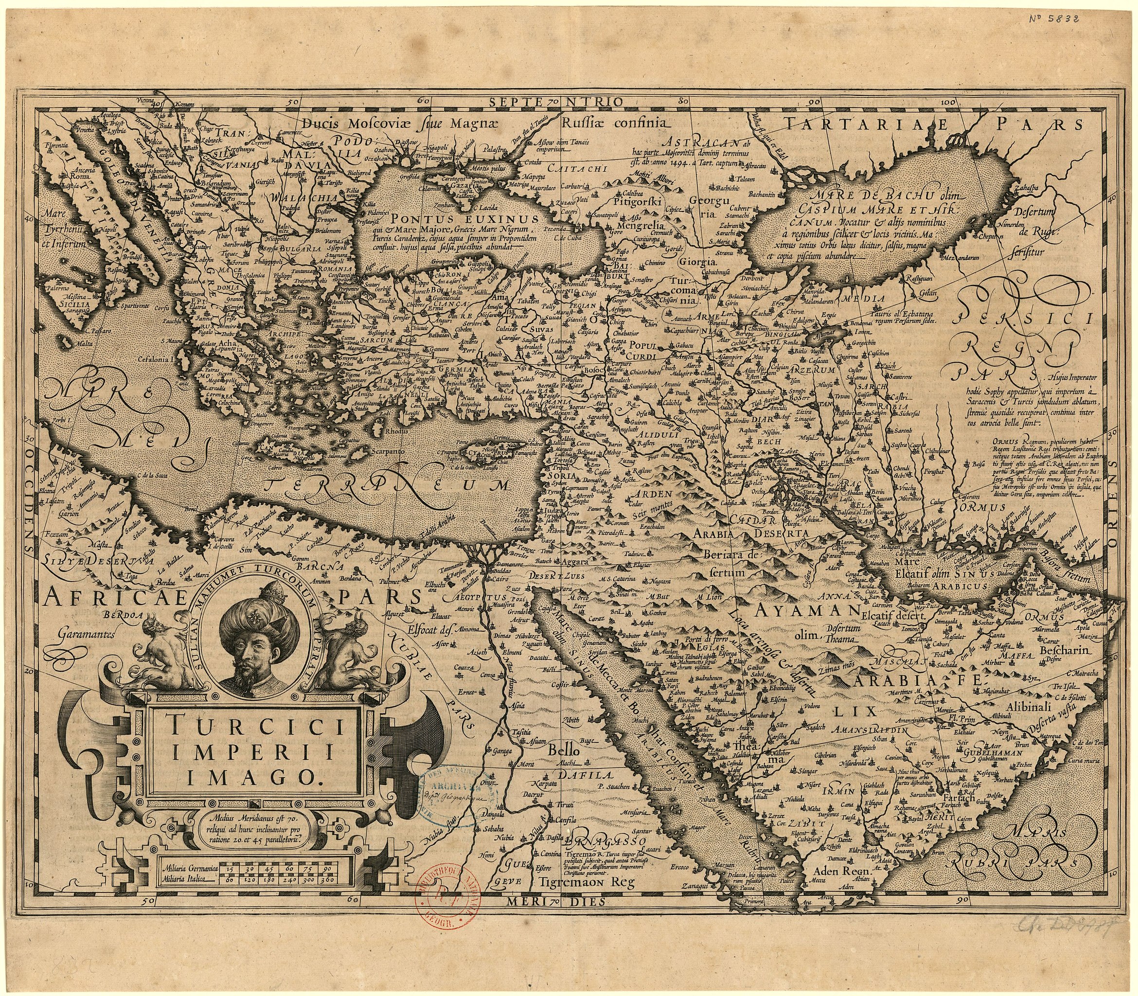
edit| Jodocus Hondius I: Turcici imperii imago
|
|||||||||||||||||||||||||||
|---|---|---|---|---|---|---|---|---|---|---|---|---|---|---|---|---|---|---|---|---|---|---|---|---|---|---|---|
| Editor |
|
_(cropped).jpg) | |||||||||||||||||||||||||
| Title |
Turcici Imperii Imago |
||||||||||||||||||||||||||
| Publisher | |||||||||||||||||||||||||||
| Object type |
antique map / manuscript map / early world maps / historical map |
||||||||||||||||||||||||||
| Genre |
map |
||||||||||||||||||||||||||
| Description |
Français : Sujet : Géographie historique
Grèce -- 1606 Turquie d'Europe -- 1606 Turquie d'Asie -- 1606 Ottoman, Empire -- 1606 Afrique -- Nord-Est -- 1606 Arabique, Péninsule -- 1606 Perse -- 1606 Europe -- Sud-Ouest -- 1606 Grande Tartarie -- 1606 Échelle(s) : [1:2 130 000 ca] Miliaria Germanica 90 = [5,2 cm], Miliaria Italica 360 = [5,2 cm] d'après échelles graphiques). Appartient à l’ensemble documentaire : AnvilGr Couverture : Grèce E 12° - E 70° / N 50° - N 12° Langue : latin Éditeur : [excusum in aedibus Iudoci Hondij] (Amsterodami) |
||||||||||||||||||||||||||
| Language |
Latin |
||||||||||||||||||||||||||
| Date | 1606 | ||||||||||||||||||||||||||
| Publication date |
possibly / 1606 |
||||||||||||||||||||||||||
| Dimensions | height: 48.5 cm (19 in); width: 36.1 cm (14.2 in) | ||||||||||||||||||||||||||
| Collection |
|
||||||||||||||||||||||||||
| Place of publication |
Amsterdam |
||||||||||||||||||||||||||
| Notes |
.jpg) |
||||||||||||||||||||||||||
| References |
Français : Notice de recueil : http://catalogue.bnf.fr/ark:/12148/cb40577015h
Appartient à : Collection d'Anville ; 05832 Notice du catalogue : http://catalogue.bnf.fr/ark:/12148/cb406048627 |
||||||||||||||||||||||||||
| Authority file | |||||||||||||||||||||||||||
| Source/Photographer |
Français : Bibliothèque nationale de France, département Cartes et plans, CPL GE DD-2987 (5832)
Bibliothèque nationale de France (1/2) |
||||||||||||||||||||||||||
| Permission (Reusing this file) |
|
||||||||||||||||||||||||||


.jpg&action=edit§ion=1)
File history
Click on a date/time to view the file as it appeared at that time.
| Date/Time | Thumbnail | Dimensions | User | Comment | |
|---|---|---|---|---|---|
| current | 06:08, 14 July 2022 | | 5,917 × 5,179 (5.61 MB) | Gzen92Bot (talk | contribs) | Gallica btv1b59622100 |
You cannot overwrite this file.
File usage on Commons
The following page uses this file:
.jpg)
.jpg&oldid=869436867)