File:Turcici imperii imago 01-map (FL10521761 2716583) (cropped).jpg

Size of this preview: 800 × 593 pixels. Other resolutions: 320 × 237 pixels | 640 × 474 pixels | 1,024 × 759 pixels | 1,280 × 948 pixels | 2,560 × 1,897 pixels | 11,537 × 8,549 pixels.
Original file (11,537 × 8,549 pixels, file size: 93.61 MB, MIME type: image/jpeg)
Captions
Captions
Add a one-line explanation of what this file represents
Summary
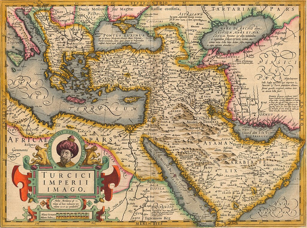
edit| Jodocus Hondius I: Turcici imperii imago
|
|||||||||||||||||||||||||||||||||||||
|---|---|---|---|---|---|---|---|---|---|---|---|---|---|---|---|---|---|---|---|---|---|---|---|---|---|---|---|---|---|---|---|---|---|---|---|---|---|
| Editor |
|
_(cropped).jpg) | |||||||||||||||||||||||||||||||||||
| Title |
Turcici imperii imago |
||||||||||||||||||||||||||||||||||||
| Publisher | |||||||||||||||||||||||||||||||||||||
| Object type |
antique map / manuscript map / early world maps / historical map |
||||||||||||||||||||||||||||||||||||
| Genre |
map |
||||||||||||||||||||||||||||||||||||
| Description |
Turcici imperii imago. |
||||||||||||||||||||||||||||||||||||
| Language |
Latin |
||||||||||||||||||||||||||||||||||||
| Date |
circa / 17th century |
||||||||||||||||||||||||||||||||||||
| Publication date |
possibly / 1606 |
||||||||||||||||||||||||||||||||||||
| Medium | 1 map : col ; | ||||||||||||||||||||||||||||||||||||
| Dimensions |
height: 48 cm (18.8 in) |
||||||||||||||||||||||||||||||||||||
| Collection |
|
||||||||||||||||||||||||||||||||||||
| Current location |
|
||||||||||||||||||||||||||||||||||||
| Place of publication |
Amsterdam |
||||||||||||||||||||||||||||||||||||
| Notes |
Probably from Mercator's Atlas.; On verso text in Latin, p. 342, signum Rrrrrrr. | ||||||||||||||||||||||||||||||||||||
| IE PID | IE10521759 | ||||||||||||||||||||||||||||||||||||
| Rosetta filename | FL10521761 | ||||||||||||||||||||||||||||||||||||
| NNL item ID (P3959) | 990027165830205171 | ||||||||||||||||||||||||||||||||||||
| References | Anna Contadini, The Renaissance and the Ottoman World | ||||||||||||||||||||||||||||||||||||
| Authority file | |||||||||||||||||||||||||||||||||||||
| Source/Photographer |
|
||||||||||||||||||||||||||||||||||||
| Other versions | |||||||||||||||||||||||||||||||||||||
| search Merhav catalog | Turcici imperii imago | ||||||||||||||||||||||||||||||||||||


.jpg)
_(cropped2).jpg)
_(cropped).jpg)
_(cropped).jpg)
_(cropped).jpg)

_(cropped).jpg&action=edit§ion=1)
Licensing
edit_(cropped).jpg&action=edit§ion=2)
The copyright situation of this work is theoretically uncertain, because in the country of origin copyright lasts 70 years after the death of the author, and the date of the author's death is unknown. However, the date of creation of the work was over 120 years ago, and it is thus a reasonable assumption that the copyright has expired (see here for the community discussion). Do not use this template if the date of death of the author is known.
| |
| This file has been identified as being free of known restrictions under copyright law, including all related and neighboring rights. | |
File history
Click on a date/time to view the file as it appeared at that time.
| Date/Time | Thumbnail | Dimensions | User | Comment | |
|---|---|---|---|---|---|
| current | 12:03, 21 July 2023 | | 11,537 × 8,549 (93.61 MB) | Geagea (talk | contribs) | c:User:Rillke/bigChunkedUpload.js: =={{int:filedesc}}== {{Artwork |artist = |author = |title = Turcici imperii imago |description = Turcici imperii imago. |language = | date = |publication date = |medium = 1 map : col ; |dimensions = |institution = |department = {{Institution:National Library of Israel}} |place of publication = |object history = |exhibition history = |credit line = |inscriptions = |notes = Probably from Mercator's Atlas.; On verso text in Lat... |
You cannot overwrite this file.
File usage on Commons
The following 12 pages use this file:
- File:Cyprus. Turcici imperii imago 01-map (FL10521761 2716583) (cropped).jpg
- File:Judæa. Turcici imperii imago 01-map (FL10521761 2716583) (cropped).jpg
- File:Map - Special Collections University of Amsterdam - OTM- HB-KZL 33.05.55.tif
- File:Pontus Euxinus. Turcici imperii imago 01-map (FL10521761 2716583) (cropped).jpg
- File:Turcici Imperii Imago - btv1b59622100 (1 of 2).jpg
- File:Turcici Imperii Imago by Jodocus Hondius I c1606.jpg
- File:Turcici imperii imago - btv1b10678482z.jpg
- File:Turcici imperii imago 01-map (FL10521761 2716583).jpg
- File:Turcici imperii imago 01-map (FL10521761 2716583).tif
- File:Turcici imperii imago 01-map (FL10521761 2716583) (cropped).jpg
- File:Turcici imperii imago 01-map (FL10521761 2716583) (cropped2).jpg
- Category:Maps of the Ottoman Empire by Mercator-Hondius
.jpg)
File usage on other wikis
The following other wikis use this file:
- Usage on fr.wikipedia.org
- Usage on he.wikipedia.org
- Usage on www.wikidata.org
_(cropped).jpg&oldid=857896749)