File:Turkey Azerbaijan Locator.png
No higher resolution available.
Turkey_Azerbaijan_Locator.png (250 × 115 pixels, file size: 7 KB, MIME type: image/png)
Captions
Captions
Add a one-line explanation of what this file represents
Summary
edit
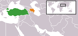
| Description | Map showing the locations of Turkey and Azerbaijan, used for bilateral relations articles, through w:template:bilateral. |
| Date | 11 June 2007 (original upload date) |
| Source | Transferred from en.wikipedia to Commons. |
| Author |
Jackaranga at English Wikipedia Later versions were uploaded by Aivazovsky, AtilimGunesBaydin at en.wikipedia. |
Licensing
edit
| This work has been released into the public domain by its author, Jackaranga at English Wikipedia. This applies worldwide. In some countries this may not be legally possible; if so: Jackaranga grants anyone the right to use this work for any purpose, without any conditions, unless such conditions are required by law. |
Original upload log
edit
The original description page was here. All following user names refer to en.wikipedia.
- 2007-06-29 11:29 AtilimGunesBaydin 250×115×8 (6714 bytes) Fixed mistake regarding Turkey's area.
- 2007-06-14 01:31 Aivazovsky 250×115×8 (6875 bytes)
- 2007-06-11 05:53 Jackaranga 250×115×8 (6957 bytes)
File history
Click on a date/time to view the file as it appeared at that time.
| Date/Time | Thumbnail | Dimensions | User | Comment | |
|---|---|---|---|---|---|
| current | 15:04, 9 September 2007 | | 250 × 115 (7 KB) | Jackaranga (talk | contribs) | {{Information |Description=}|2={{{2|no}}}}} == Summary == Created from a crop of a public domain map Made for use in en:Turkey-Germany relations, can be used anywhere |Source=Originally from [http://en.wikipedia.org en.wikipedia]; description page is |
You cannot overwrite this file.
File usage on Commons
There are no pages that use this file.
File usage on other wikis
The following other wikis use this file:
- Usage on de.wikipedia.org
- Usage on en.wikipedia.org
- Usage on fa.wikipedia.org