File:TurkicLanguageMap.svg

Size of this PNG preview of this SVG file: 800 × 406 pixels. Other resolutions: 320 × 162 pixels | 640 × 325 pixels | 1,024 × 520 pixels | 1,280 × 650 pixels | 2,560 × 1,300 pixels | 2,754 × 1,398 pixels.
Original file (SVG file, nominally 2,754 × 1,398 pixels, file size: 1.27 MB)
Captions
Captions
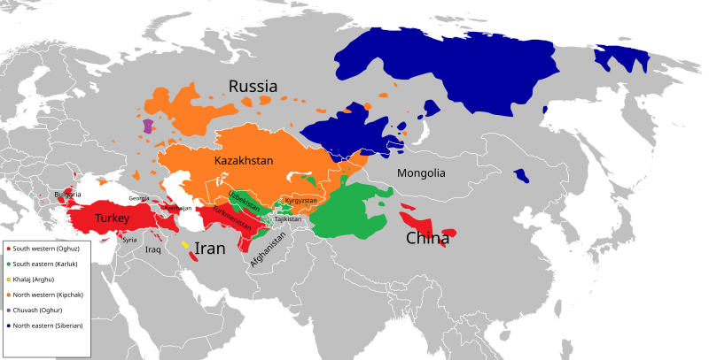
Turkic Language Map
Summary edit
| Description |
English: A map showing areas where Turkic languages are spoken. Vectorised version of a rasterised map made by Mirza Farahani.
Southwestern (Oghuz)
Southeastern (Karluk)
Khalaj (Arghu)
Northwestern (Kipchak)
Chuvash (Oghur)
Northeastern (Siberian) Svenska: En karta som visar utbredningen av turkiska språk. Vektoriserad version av en rasteriserad karta ursprungligen gjord av Mirza Farahani.
Sydvästturkiska språk (Oghuz)
Sydöstturkiska språk (Karluk)
Chaladjiska (Arghu)
Nordvästturkiska språk (Kipchak)
Tjuvasjiska (Oghur)
Nordöstturkiska språk (Sibiriska) |
| Date | |
| Source | https://en.wikipedia.org/wiki/File:TurkicMapAccurate.png |
| Author | Mirza Farahani |
| Other versions |
|
.svg)
Licensing edit
This file is licensed under the Creative Commons Attribution-Share Alike 4.0 International license.
- You are free:
- to share – to copy, distribute and transmit the work
- to remix – to adapt the work
- Under the following conditions:
- attribution – You must give appropriate credit, provide a link to the license, and indicate if changes were made. You may do so in any reasonable manner, but not in any way that suggests the licensor endorses you or your use.
- share alike – If you remix, transform, or build upon the material, you must distribute your contributions under the same or compatible license as the original.
File history
Click on a date/time to view the file as it appeared at that time.
| Date/Time | Thumbnail | Dimensions | User | Comment | |
|---|---|---|---|---|---|
| current | 15:49, 8 April 2020 | | 2,754 × 1,398 (1.27 MB) | Lysol90 (talk | contribs) | Cleaned up a bit and added names of important countries. |
| 21:47, 5 April 2020 |  | 2,754 × 1,398 (566 KB) | Lysol90 (talk | contribs) | Uploaded a work by Mirza Farahani from https://en.wikipedia.org/wiki/File:TurkicMapAccurate.png with UploadWizard |
You cannot overwrite this file.
File usage on Commons
The following 4 pages use this file:
File usage on other wikis
The following other wikis use this file:
- Usage on crh.wikipedia.org
- Usage on he.wikipedia.org
- Usage on uk.wikipedia.org
- Usage on www.wikidata.org