File:Tyonek-Airport-diagram.png
No higher resolution available.
Tyonek-Airport-diagram.png (496 × 570 pixels, file size: 45 KB, MIME type: image/png)
Captions
Captions
Add a one-line explanation of what this file represents
Summary
edit
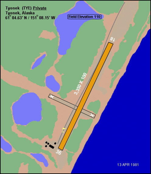
| Description | Diagram of Tyonek Airport (FAA: TYE) in Tyonek, Alaska, United States. |
| Date | |
| Source |
|
| Author | Federal Aviation Administration, Alaskan Region |
| Permission (Reusing this file) |
Public domain |
| Object location | | View this and other nearby images on: OpenStreetMap |
|---|
Licensing
edit
This image or file is a work of a Federal Aviation Administration employee, taken or made as part of that person's official duties. As a work of the U.S. federal government, the image is in the public domain in the United States.
|
 |
File history
Click on a date/time to view the file as it appeared at that time.
| Date/Time | Thumbnail | Dimensions | User | Comment | |
|---|---|---|---|---|---|
| current | 04:11, 18 June 2010 | | 496 × 570 (45 KB) | Zyxw (talk | contribs) | __NOTOC__ == {{int:filedesc}} == {{Information | description = Diagram of {{w|Tyonek Airport}} (FAA: TYE) in Tyonek, Alaska, United States. | date = 1981-04-13 | source = * Image: {{cite web | url = http://www.alaska.faa.gov/fai/images/ARPT_DIAGRAMS/TY |
You cannot overwrite this file.
File usage on Commons
There are no pages that use this file.
File usage on other wikis
The following other wikis use this file:
- Usage on arz.wikipedia.org
- Usage on ceb.wikipedia.org
- Usage on en.wikipedia.org
- Usage on fa.wikipedia.org
- Usage on ro.wikipedia.org
- Usage on ru.wikipedia.org
- Usage on tg.wikipedia.org
- Usage on www.wikidata.org