File:Typhoon Chan-hom (MODIS 2020-10-08).jpg

Size of this preview: 711 × 600 pixels. Other resolutions: 285 × 240 pixels | 569 × 480 pixels | 910 × 768 pixels | 1,214 × 1,024 pixels | 2,428 × 2,048 pixels | 4,745 × 4,003 pixels.
Original file (4,745 × 4,003 pixels, file size: 2.5 MB, MIME type: image/jpeg)
Captions
Captions
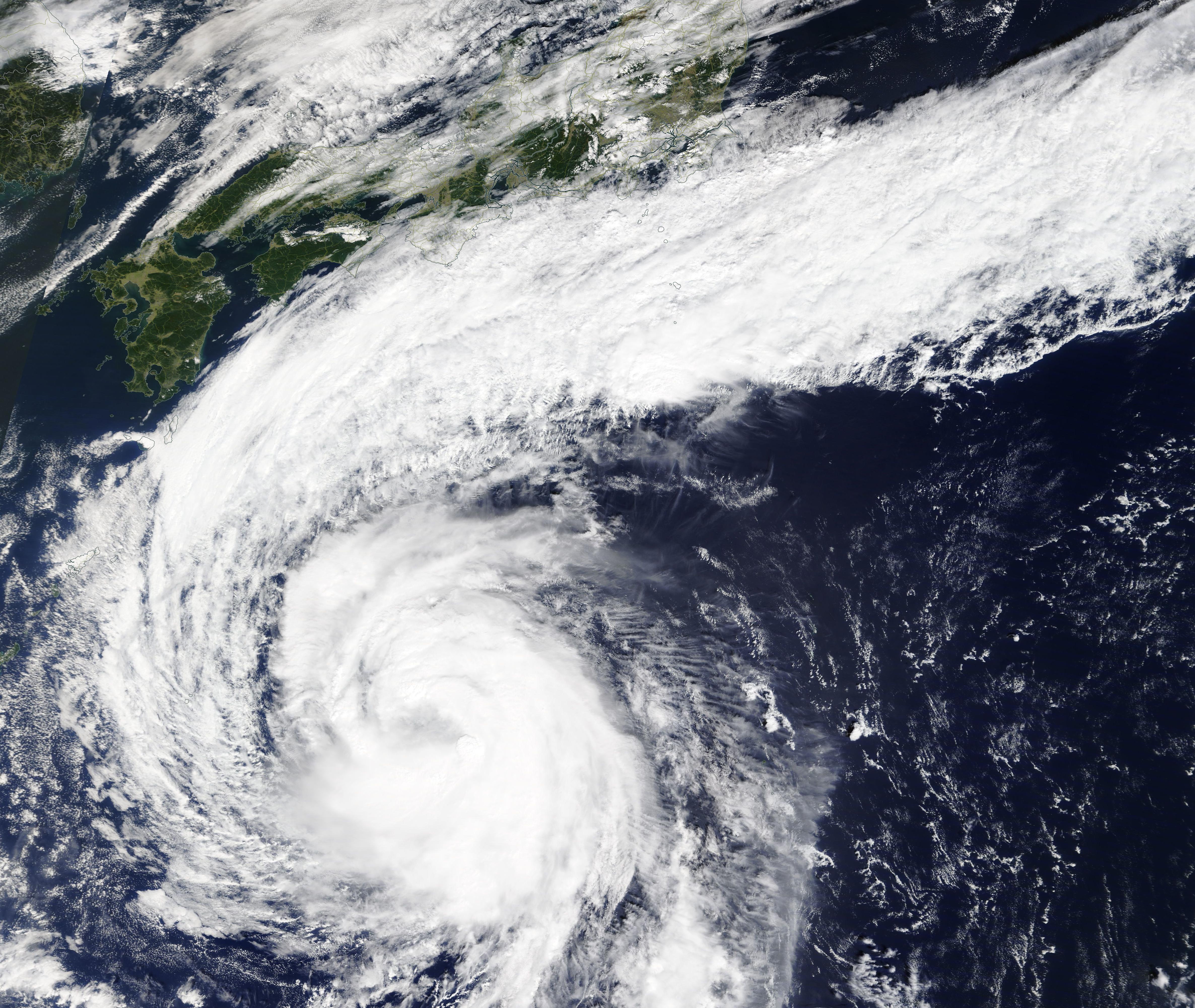
The Moderate Resolution Imaging Spectroradiometer (MODIS) on board NASA’s Terra satellite acquired a true-color image of Chan-hom as it was transitioning from a tropical storm to a typhoon on that same day.
Summary
edit.jpg&action=edit§ion=1)
| Description |
English: On October 7, 2020, Typhoon Chan-hom was spinning and strengthening over the Western Pacific Ocean. The Moderate Resolution Imaging Spectroradiometer (MODIS) on board NASA’s Terra satellite acquired a true-color image of Chan-hom as it was transitioning from a tropical storm to a typhoon on that same day. The image showed that Typhoon Chan-hom sported a ragged cloud-filled eye with northeasterly frontal flow wrapping into the storm.
At 2100 UTC (5 p.m. EDT) on October 7, the Joint Typhoon Warning Center (JTWC) stated that Chan-hom was located about 323 mi (520 km) east of Kadena Air Base, Okinawa, Japan. Maximum sustained winds were registered at about 80.5 mph (129.5 km/h) and the storm was moving to the northwestward at 9 mph (14 km/h). Environmental conditions remain favorable, with low vertical wind shear and warm sea surface temperatures. Typhoon Chan-hom is forecast to turn poleward and track northwest to northward for the next 36 hours as it recurves. The JTWC states that there is still uncertainty with how tight the turn toward the northeast will be, which will greatly influence potential impacts to mainland Japan. It is expected to strengthen to about 92 mph (148 km/h) on October 8. After that time, it is forecast to accelerate east-northeastward along and near the southern coast of Japan. During that time, the forecast is for Chan-hom to steadily weaken for the next several days. |
||
| Date | Taken on 7 October 2020 | ||
| Source |
Typhoon Chan-hom (direct link)
|
||
| Author | MODIS Land Rapid Response Team, NASA GSFC |
| This media is a product of the Terra mission Credit and attribution belongs to the mission team, if not already specified in the "author" row |
Licensing
edit.jpg&action=edit§ion=2)
| This file is in the public domain in the United States because it was solely created by NASA. NASA copyright policy states that "NASA material is not protected by copyright unless noted". (See Template:PD-USGov, NASA copyright policy page or JPL Image Use Policy.) | ||
 |
Warnings:
|
File history
Click on a date/time to view the file as it appeared at that time.
| Date/Time | Thumbnail | Dimensions | User | Comment | |
|---|---|---|---|---|---|
| current | 19:50, 7 February 2024 | | 4,745 × 4,003 (2.5 MB) | OptimusPrimeBot (talk | contribs) | #Spacemedia - Upload of http://modis.gsfc.nasa.gov/gallery/images/image10082020_500m.jpg via Commons:Spacemedia |
You cannot overwrite this file.
File usage on Commons
There are no pages that use this file.
.jpg&oldid=849873223)