File:Typhoon Sonca 2005.jpg

Size of this preview: 600 × 600 pixels. Other resolutions: 240 × 240 pixels | 480 × 480 pixels | 768 × 768 pixels | 1,024 × 1,024 pixels | 2,048 × 2,048 pixels | 5,400 × 5,400 pixels.
Original file (5,400 × 5,400 pixels, file size: 3.32 MB, MIME type: image/jpeg)
Captions
Captions
Add a one-line explanation of what this file represents
Summary edit
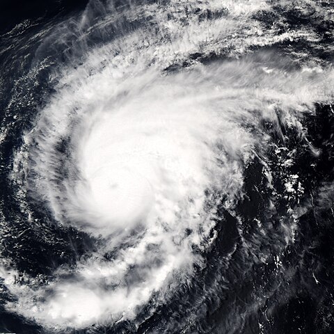
| Description | Typhoon Sonca was just beginning to weaken on April 25, 2005, when the Moderate Resolution Imaging Spectroradiometer (MODIS) on NASA’s Aqua satellite captured this image of the storm. Sonca is spinning across the Philippine Sea, heading towards Iwo Jima island south of Japan’s main island, Honshu. At the time this image was taken at 04:10 UTC, the storm’s winds were slowing from 213 kilometers per hour (132 mph) with gusts to 259 kph (161 mph) to 204 kph (127 mph) with gusts to 250 kph (155 mph). An eye is barely visible as a circular smudge in the center of the storm. The storm is predicted to continue to weaken. | |||||
| Date | ||||||
| Source | http://earthobservatory.nasa.gov/NaturalHazards/natural_hazards_v2.php3?img_id=12838 | |||||
| Author | NASA image created by Jesse Allen, Earth Observatory, using data obtained from the MODIS Rapid Response team. | |||||
| Permission (Reusing this file) |
|

File history
Click on a date/time to view the file as it appeared at that time.
| Date/Time | Thumbnail | Dimensions | User | Comment | |
|---|---|---|---|---|---|
| current | 15:27, 6 September 2006 | | 5,400 × 5,400 (3.32 MB) | Good kitty (talk | contribs) | == Summary == {{Information |Description=Typhoon Sonca was just beginning to weaken on April 25, 2005, when the Moderate Resolution Imaging Spectroradiometer (MODIS) on NASA’s Aqua satellite captured this image of the storm. Sonca is spinning across the |
You cannot overwrite this file.
File usage on Commons
There are no pages that use this file.
File usage on other wikis
The following other wikis use this file:
- Usage on en.wikipedia.org
- Usage on ja.wikipedia.org
- Usage on zh.wikipedia.org