File:Typhoon Surigae (Bising) in the Pacific Ocean.jpg

Original file (4,800 × 3,980 pixels, file size: 16.8 MB, MIME type: image/jpeg)
Captions
Captions
Summary
edit_in_the_Pacific_Ocean.jpg&action=edit§ion=1)
| Description |
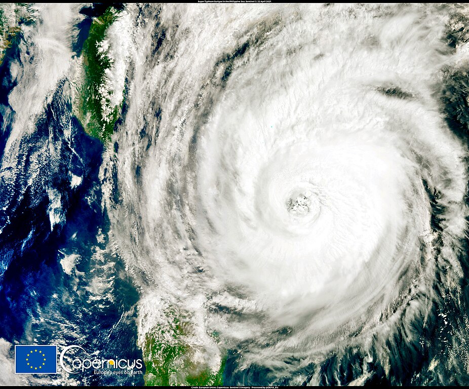
English: This image, acquired by one of the Copernicus Sentinel-3 satellites on 22 April 2021 at 01:44 UTC, shows Typhoon Surigae (known as Typhoon Bising in the Philippines) in the Pacific Ocean, hovering between the Philippines and Taiwan. Surigae is the first typhoon of the 2021 Pacific typhoon season. Its strength has been determined to be equivalent to a Category 5 major hurricane on the Saffir–Simpson Hurricane Wind Scale, and it took the typhoon only 36 hours to reach maximum winds of 305 km/h and a minimum barometric pressure of 888 hPa, an extremely low value for a tropical system. Surigae has become the most intense typhoon ever recorded in the month of April and the first tropical cyclone in the Northern Hemisphere to reach a barometric pressure below 900 hPa before the first of May, beating the previous record of 935 hPa, set by Typhoon Maysak in 2015. Data derived from images acquired by the Copernicus Sentinel-3 mission enable improvements in the scientific understanding of the composition of the atmosphere and provide essential information for climate studies and weather forecasting. |
| Date | Taken on 22 April 2021 |
| Source | Typhoon Surigae (Bising) in the Pacific Ocean |
| Author | European Union, Copernicus Sentinel-3 imagery |
Licensing
edit_in_the_Pacific_Ocean.jpg&action=edit§ion=2)

|
This image contains data from a satellite in the Copernicus Programme, such as Sentinel-1, Sentinel-2 or Sentinel-3. Attribution is required when using this image.
Attribution: Contains modified Copernicus Sentinel data 2021
The use of Copernicus Sentinel Data is regulated under EU law (Commission Delegated Regulation (EU) No 1159/2013 and Regulation (EU) No 377/2014). Relevant excerpts:
Free access shall be given to GMES dedicated data [...] made available through GMES dissemination platforms [...].
Access to GMES dedicated data [...] shall be given for the purpose of the following use in so far as it is lawful:
GMES dedicated data [...] may be used worldwide without limitations in time.
GMES dedicated data and GMES service information are provided to users without any express or implied warranty, including as regards quality and suitability for any purpose. |
File history
Click on a date/time to view the file as it appeared at that time.
| Date/Time | Thumbnail | Dimensions | User | Comment | |
|---|---|---|---|---|---|
| current | 09:05, 28 August 2023 | | 4,800 × 3,980 (16.8 MB) | OptimusPrimeBot (talk | contribs) | #Spacemedia - Upload of https://www.copernicus.eu/system/files/2021-04/image_day/20210423_SuperTyphoonSurigae_largeview.jpg via Commons:Spacemedia |
You cannot overwrite this file.
File usage on Commons
There are no pages that use this file.
_in_the_Pacific_Ocean.jpg&oldid=796637500)