File:Typus orbis terrarum - Norman B. Leventhal Map Center at the BPL.jpg

Size of this preview: 800 × 600 pixels. Other resolutions: 320 × 240 pixels | 640 × 480 pixels | 1,024 × 768 pixels | 1,280 × 960 pixels | 2,560 × 1,920 pixels | 10,880 × 8,160 pixels.
Original file (10,880 × 8,160 pixels, file size: 25.55 MB, MIME type: image/jpeg)
Captions
Captions
Add a one-line explanation of what this file represents
Summary edit
| Warning | The original file is very high-resolution. It might not load properly or could cause your browser to freeze when opened at full size. |
|---|
| Description |
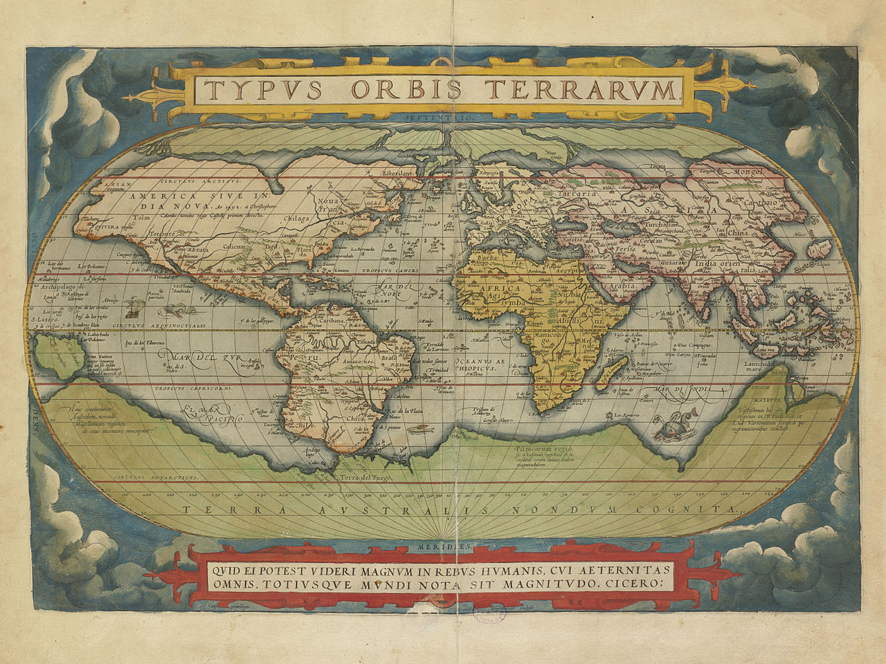
Zoom into this map at maps.bpl.org. Author: Ortelius, Abraham Publisher: A. Ortelius Date: 1570.
BPL Call Number: G1006 .T54 1570 View at the Norman B. Leventhal Map Center Ortelius' book of maps, first published in 1570, is considered the first modern world atlas. It was the first time that a set of maps, contemporary to the date of publication, was designed, drawn, and engraved with the intention of publishing them in a bound volume. Ortelius did not refer to his publication as an "atlas," as we know it today. Rather he entitled it "Theater of the World" implying not only that the entire known world could be viewed in this one book, but that the Earth was a stage on which human actions unfolded. Although most of the maps in this book pertain to European countries and provinces, it can be considered a world atlas because it also includes a map of the world (displayed here), as well as one map for each of the four continents. This world map was based on a large 21-sheet world map published by Ortelius' colleague, Gerard Mercator the year before. It displayed almost a century of European exploration in the Americas delineating relatively accurate coast lines in the Equatorial areas, but with greatly distorted shapes in southern South America and northern and western North America. Interestingly, the map prematurely showed a southern polar continent since the southern oceans had not yet been explored. The projected southern continent was based on the reports of Magellan sighting Terra del Fuego when he rounded the tip of South America and the accounts of early Dutch discoveries along the Australian coast. While the first edition of Ortelius' Theatrum Orbis Terrarum was published in Latin in 1570, this map book was subsequently issued in 33 editions over the next 41 years. It was also translated into six other languages -- German, Dutch, French, Spanish, Italian, and English. The success of this first "atlas" publication marked the beginning of the golden age of Flemish and Dutch cartography with cartographers from the Low Countries dominating the map trade until the end of the 17th century. |
| Date | |
| Source | Typus orbis terrarum |
| Author | http://maps.bpl.org |
Licensing edit
This file is licensed under the Creative Commons Attribution 2.0 Generic license.
- You are free:
- to share – to copy, distribute and transmit the work
- to remix – to adapt the work
- Under the following conditions:
- attribution – You must give appropriate credit, provide a link to the license, and indicate if changes were made. You may do so in any reasonable manner, but not in any way that suggests the licensor endorses you or your use.
| This image was originally posted to Flickr by Norman B. Leventhal Map Center at the BPL at https://www.flickr.com/photos/24528911@N05/2710792122. It was reviewed on 2 July 2012 by FlickreviewR and was confirmed to be licensed under the terms of the cc-by-2.0. |
File history
Click on a date/time to view the file as it appeared at that time.
| Date/Time | Thumbnail | Dimensions | User | Comment | |
|---|---|---|---|---|---|
| current | 09:38, 26 August 2014 | | 10,880 × 8,160 (25.55 MB) | Joopr (talk | contribs) | Geconverteerd JP2 bestand in zo groot mogelijke resolutie. Geplaatst omdat de oorspronkelijke webpagina (tijdelijk?) niet meer beschikbaar is. |
| 01:42, 2 July 2012 |  | 1,200 × 900 (352 KB) | Dzlinker (talk | contribs) | == {{int:filedesc}} == {{Information |Description=Zoom into [http://maps.bpl.org/id/M8747/ this map] at [http://maps.bpl.org maps.bpl.org]. '''Author:''' Ortelius, Abraham '''Publisher:''' A. Ortelius '''Date:''' 1570. '''Scale:''' Scale not given. '... |
You cannot overwrite this file.
File usage on Commons
There are no pages that use this file.
File usage on other wikis
The following other wikis use this file:
- Usage on en.wikipedia.org
- Usage on fr.wikipedia.org