File:U45 Törnby - KMB - 16001000326964.jpg
Size of this preview: 399 × 599 pixels. Other resolutions: 160 × 240 pixels | 524 × 787 pixels.
Original file (524 × 787 pixels, file size: 152 KB, MIME type: image/jpeg)
Captions
Captions
Add a one-line explanation of what this file represents
| Camera location | | View this and other nearby images on: OpenStreetMap |
|---|
| U45 Törnby
( |
|||||||||||||||||||||||||||
|---|---|---|---|---|---|---|---|---|---|---|---|---|---|---|---|---|---|---|---|---|---|---|---|---|---|---|---|
| Photographer |
|
||||||||||||||||||||||||||
| Title |
U45 Törnby |
||||||||||||||||||||||||||
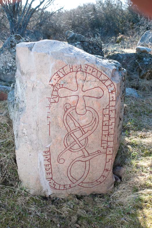
| Original caption |
Notera Av dokumentationsskäl har originalbeskrivningen från Riksantikvarieämbetet behållits. Tillrättalägganden och alternativa beskrivningar bör införas separat från nedanstående information. RAÄ-nummer Skå 16:1. Inskriften lyder: "Saxe lät hugga stenen och göra bro efter....., sin moder".Felaktigheter kan även anmälas till denna sida. Motiv: Skå 16:1 |
||||||||||||||||||||||||||
| Description |
RAÄ-nummer Skå 16:1. Inskriften lyder: "Saxe lät hugga stenen och göra bro efter....., sin moder". Skå 16:1.
|
||||||||||||||||||||||||||
| Depicted place | Sweden, Uppsala Municipality, Skå socken | ||||||||||||||||||||||||||
| Date | 18 April 2011 | ||||||||||||||||||||||||||
| Collection |
|
||||||||||||||||||||||||||
| Accession number | |||||||||||||||||||||||||||
| Source |
Bengt A Lundberg / Kulturmiljöbild, Riksantikvarieämbetet
|
||||||||||||||||||||||||||
| Permission (Reusing this file) |
This file is licensed under the Creative Commons Attribution 2.5 Generic license. Attribution: Bengt A Lundberg / Riksantikvarieämbetet
|
||||||||||||||||||||||||||


| Object location | | View this and other nearby images on: OpenStreetMap |
|---|
File history
Click on a date/time to view the file as it appeared at that time.
| Date/Time | Thumbnail | Dimensions | User | Comment | |
|---|---|---|---|---|---|
| current | 01:28, 10 June 2017 | | 524 × 787 (152 KB) | AndreCostaWMSE-bot (talk | contribs) | {{Kulturmiljöbild-image | short title = U45 Törnby | original description = RAÄ-nummer Skå 16:1. Inskriften lyder: "Saxe lät hugga stenen och göra bro efter....., sin moder".<br> Motiv: Skå 16:1<br> Nyckelord: Runor<br> Kategori: Runristning/run... |
You cannot overwrite this file.
File usage on Commons
The following 2 pages use this file:
File usage on other wikis
The following other wikis use this file:
- Usage on da.wikipedia.org
- Usage on sv.wikipedia.org
- Usage on www.wikidata.org