File:UK Radar1940.JPG

Size of this preview: 502 × 599 pixels. Other resolutions: 201 × 240 pixels | 402 × 480 pixels | 644 × 768 pixels | 858 × 1,024 pixels | 1,400 × 1,670 pixels.
Original file (1,400 × 1,670 pixels, file size: 304 KB, MIME type: image/jpeg)
Captions
Captions
Add a one-line explanation of what this file represents
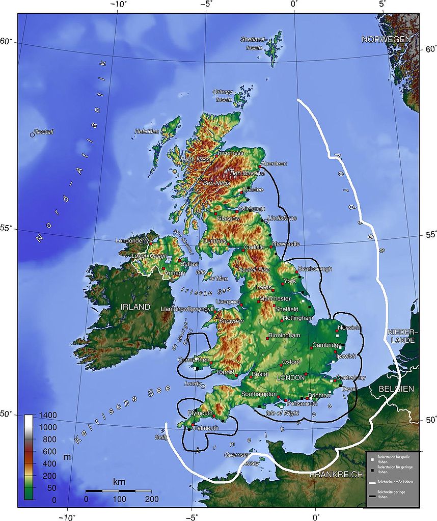
The map (topographic background derived from a German article about Great Britain taken from German wikipedia) gives a quick overview about British radar facilities during the Battle for Britain 1940. I drew the map myself (thats the reason, why it looks quite improvised). Nasiruddin 16:27, 15 August 2005 (UTC)
- Explanation of German legend: White squares indicate high-altitude radar stations, black squares, low-altitude stations. The white line indicates the range of the high-altitude radar, the black line, the range of the low altitude radar.
- other versions =


- other versions =


The map has been created with the Generic Mapping Tools: https://www.generic-mapping-tools.org/ using one or more of these public-domain datasets for the relief:
|

|
Permission is granted to copy, distribute and/or modify this document under the terms of the GNU Free Documentation License, Version 1.2 or any later version published by the Free Software Foundation; with no Invariant Sections, no Front-Cover Texts, and no Back-Cover Texts. A copy of the license is included in the section entitled GNU Free Documentation License. |
| This file is licensed under the Creative Commons Attribution-Share Alike 3.0 Unported license. | ||
| ||
| This licensing tag was added to this file as part of the GFDL licensing update. |
File history
Click on a date/time to view the file as it appeared at that time.
| Date/Time | Thumbnail | Dimensions | User | Comment | |
|---|---|---|---|---|---|
| current | 16:27, 15 August 2005 | | 1,400 × 1,670 (304 KB) | Nasiruddin (talk | contribs) | The map (topographic background derived from a German article about Great Britain taken from German wikipedia) gives a quick overview about British radar facilities during the Battle for Britain 1940. I drew the map myself (thats the reason, why it looks |
You cannot overwrite this file.
File usage on Commons
The following 4 pages use this file:
File usage on other wikis
The following other wikis use this file:
- Usage on ca.wikipedia.org
- Usage on de.wikipedia.org
- Usage on fi.wikipedia.org
- Usage on fr.wikipedia.org
- Usage on hi.wikipedia.org
- Usage on hu.wikipedia.org
- Usage on ko.wikipedia.org
- Usage on pt.wikipedia.org
- Usage on sv.wikipedia.org
- Usage on vi.wikipedia.org