File:UNOSAT Gaza WV Damage Overview 10Jan09 Highres v2.page1.png
Size of this preview: 800 × 566 pixels. Other resolutions: 320 × 226 pixels | 640 × 453 pixels | 1,024 × 725 pixels | 1,280 × 906 pixels | 1,587 × 1,123 pixels.
Original file (1,587 × 1,123 pixels, file size: 2.37 MB, MIME type: image/png)
Captions
Captions
Add a one-line explanation of what this file represents
Summary edit
| Description |
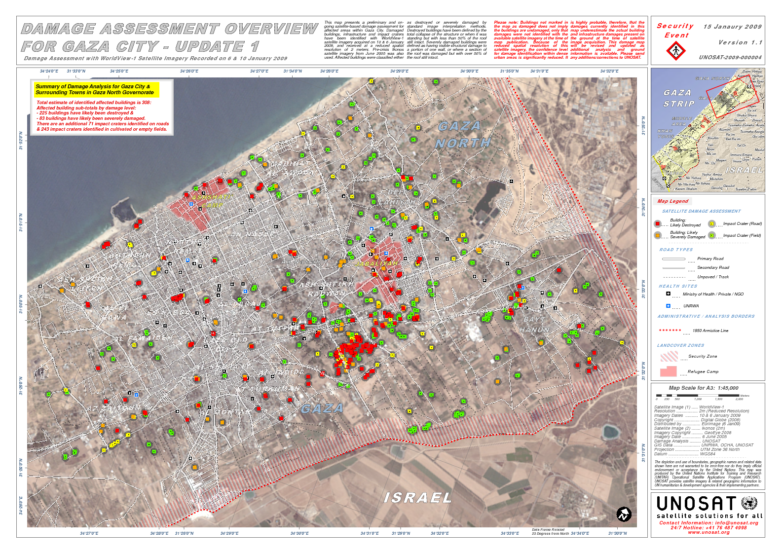
English: According to UNOSAT, "This map presents a preliminary and on-going satellite-based damage assessment for affected areas within Gaza City..satellite imagery acquired on 10 & 6 January 2009"
Source(s): Satellite Image (1) : WorldView-1 Resolution : 2m (Reduced Resolution) Imagery Dates : 10 & 6 January 2009 Copyright : Digital Globe (2008) Distributed by : Eurimage (6 Jan09) Satellite Image (2) : Ikonos (2m) Imagery Copyright : GeoEye 2008 Imagery Date : 6 June 2005 Damage Analysis : UNOSAT GIS Data : UNRWA, OCHA, GIST, UNOSAT |
| Date | |
| Source | http://unosat.web.cern.ch/unosat/freeproducts/Gaza/Crisis2008/UNOSAT_Gaza_WV_Damage_Overview_10Jan09_Highres_v2.pdf |
| Author | UNOSAT |
Licensing edit

|
The copyright holder of this file allows anyone to use it for any purpose, provided that the copyright holder is properly attributed. Redistribution, derivative work, commercial use, and all other use is permitted. |
|
|
File history
Click on a date/time to view the file as it appeared at that time.
| Date/Time | Thumbnail | Dimensions | User | Comment | |
|---|---|---|---|---|---|
| current | 04:55, 10 March 2009 | | 1,587 × 1,123 (2.37 MB) | Falastine fee Qalby (talk | contribs) | {{Information |Description={{en|1=According to UNOSAT, "This map presents a preliminary and on-going satellite-based damage assessment for affected areas within Gaza City..satellite imagery acquired on 10 & 6 January 2009" Source(s): Satellite Image (1) |
You cannot overwrite this file.
File usage on Commons
There are no pages that use this file.
File usage on other wikis
The following other wikis use this file:
- Usage on fi.wikipedia.org
- Usage on hr.wikipedia.org
- Usage on nl.wikipedia.org
- Usage on sh.wikipedia.org