File:UNR 1918 divisions-0.png
Size of this preview: 800 × 491 pixels. Other resolutions: 320 × 197 pixels | 640 × 393 pixels | 1,024 × 629 pixels | 1,280 × 786 pixels | 1,687 × 1,036 pixels.
Original file (1,687 × 1,036 pixels, file size: 290 KB, MIME type: image/png)
Captions
Captions
Add a one-line explanation of what this file represents
| Description |
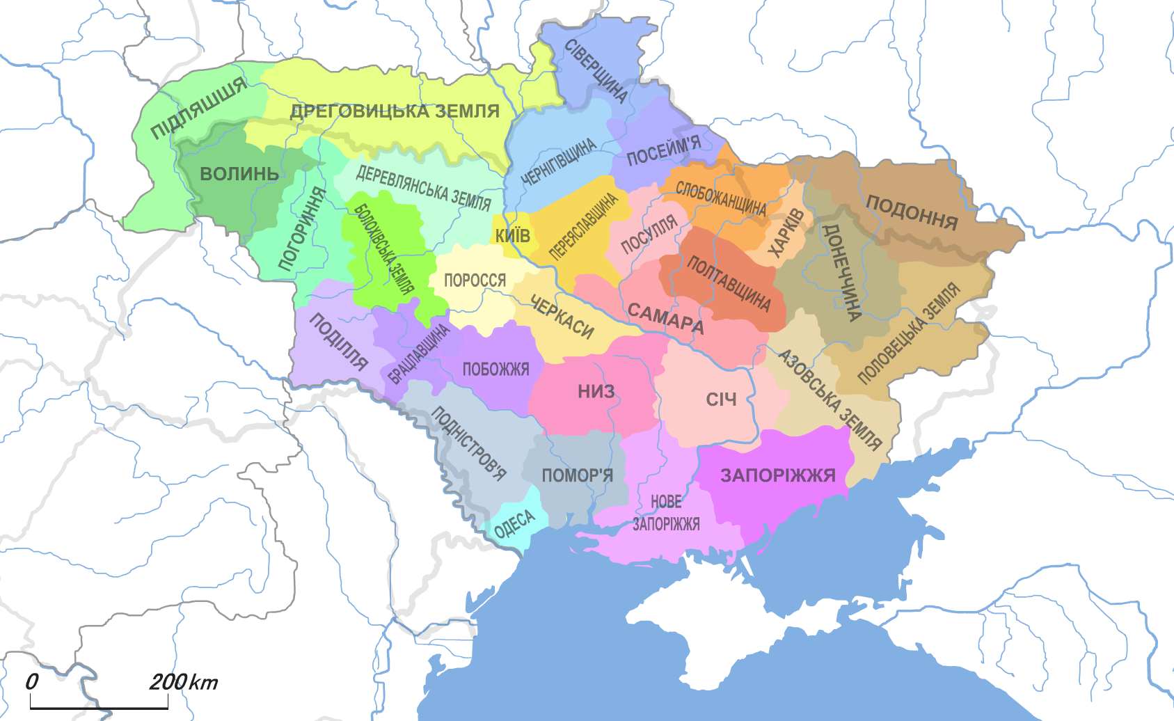
Українська: Адміністративна карта Української Народної Республіки (1918.III)
English: Administrative map of the Ukrainian People's Republic (1918.III)
日本語: ウクライナ共和国の行政区分図 (1918年3月) |
| Date | |
| Source | Own work, based on Початок визвольних змагань українського народу. Утворення УНР (березень 1917 - березень 1918 р) // Атлас історії України. 10 клас |
| Author | Alex Tora |
This file is licensed under the Creative Commons Attribution-Share Alike 2.1 Japan license.
- You are free:
- to share – to copy, distribute and transmit the work
- to remix – to adapt the work
- Under the following conditions:
- attribution – You must give appropriate credit, provide a link to the license, and indicate if changes were made. You may do so in any reasonable manner, but not in any way that suggests the licensor endorses you or your use.
- share alike – If you remix, transform, or build upon the material, you must distribute your contributions under the same or compatible license as the original.

File history
Click on a date/time to view the file as it appeared at that time.
| Date/Time | Thumbnail | Dimensions | User | Comment | |
|---|---|---|---|---|---|
| current | 17:48, 16 November 2023 | | 1,687 × 1,036 (290 KB) | Super Dromaeosaurus (talk | contribs) | Fixed Romanian-Ukrainian border at Budjak, also a small thing in Dobruja |
| 09:26, 21 January 2012 |  | 1,687 × 1,036 (380 KB) | Alex Tora (talk | contribs) | {{Information |Description={{uk|Адміністративна карта Української Народної Республіки (1918.III)}} {{legend|#A0FF53|[[:uk:Болохівсь� |
You cannot overwrite this file.
File usage on Commons
The following page uses this file:
File usage on other wikis
The following other wikis use this file:
- Usage on be-tarask.wikipedia.org
- Usage on en.wikipedia.org
- Usage on es.wikipedia.org
- Usage on rue.wikipedia.org
- Usage on ru.wikipedia.org
- Usage on sr.wikipedia.org
- Usage on th.wikipedia.org
- Usage on uk.wikipedia.org
- Полтавщина (УНР)
- Подоння (УНР)
- Сіверщина (УНР)
- Січ (УНР)
- Самарська земля
- Київ (УНР)
- Деревська земля
- Волинь (УНР)
- Погорина (УНР)
- Болохівська земля (УНР)
- Поросся (УНР)
- Черкаська земля
- Побожжя (УНР)
- Поділля (УНР)
- Брацлавщина (УНР)
- Помор'я (УНР)
- Одеса (УНР)
- Низ (УНР)
- Запоріжжя (УНР)
- Нове Запоріжжя (УНР)
- Азовська земля
- Половецька земля (УНР)
- Чернігівщина (УНР)
- Переяславщина (УНР)
- Слобожанщина (УНР)
- Харків (УНР)
- Донеччина (УНР)
- Посем'я (УНР)
- Посулля (УНР)
- Користувач:Alex Blokha/Дні згадані в Вікіпедії/Україна/6 березня
- Користувач:Alex Blokha/Дні згадані в Вікіпедії/Україна/29 квітня
- Дреговицька земля
- Підляшшя (УНР)
- Закон про поділ України на землі
- Вікіпедія:Статті-кандидати на вилучення/5 лютого 2016
- Пінщина
- Usage on www.wikidata.org