File:UNf1941 Granby - KMB - 16000300026866.jpg
No higher resolution available.
UNf1941_Granby_-_KMB_-_16000300026866.jpg (768 × 512 pixels, file size: 227 KB, MIME type: image/jpeg)
Captions
Captions
Add a one-line explanation of what this file represents
| UNf1941 Granby
( |
|||||||||||||||||||||||||||
|---|---|---|---|---|---|---|---|---|---|---|---|---|---|---|---|---|---|---|---|---|---|---|---|---|---|---|---|
| Photographer |
|
||||||||||||||||||||||||||
| Title |
UNf1941 Granby |
||||||||||||||||||||||||||
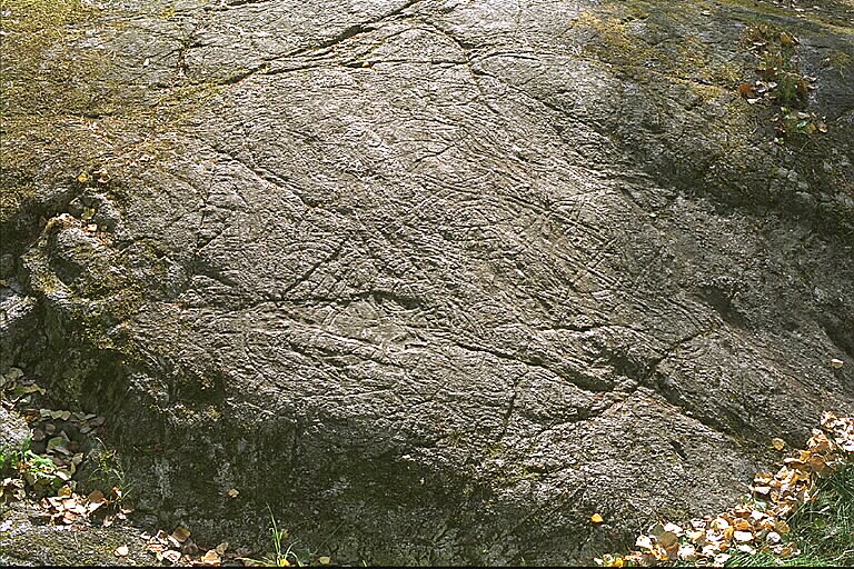
| Original caption |
Notera Av dokumentationsskäl har originalbeskrivningen från Riksantikvarieämbetet behållits. Tillrättalägganden och alternativa beskrivningar bör införas separat från nedanstående information. Inskriften på runhällen lyder: Ingelög lät hugga denna häll efter sin son Sigfast och Sig .. (?), hans broder (lät också hugga). De moder och som, bo i Hu..Felaktigheter kan även anmälas till denna sida. Motiv: UNf1941 Granby |
||||||||||||||||||||||||||
| Description |
Inskriften på runhällen lyder: Ingelög lät hugga denna häll efter sin son Sigfast och Sig .. (?), hans broder (lät också hugga). De moder och som, bo i Hu.
|
||||||||||||||||||||||||||
| Depicted place | Sweden, Stockholm Municipality, Stockholm City | ||||||||||||||||||||||||||
| Date | 27 July 1999 | ||||||||||||||||||||||||||
| Collection |
|
||||||||||||||||||||||||||
| Accession number | |||||||||||||||||||||||||||
| Source |
Bengt A Lundberg / Kulturmiljöbild, Riksantikvarieämbetet
|
||||||||||||||||||||||||||
| Permission (Reusing this file) |
This file is licensed under the Creative Commons Attribution 2.5 Generic license. Attribution: Bengt A Lundberg / Riksantikvarieämbetet
|
||||||||||||||||||||||||||


| Object location | | View this and other nearby images on: OpenStreetMap |
|---|
File history
Click on a date/time to view the file as it appeared at that time.
| Date/Time | Thumbnail | Dimensions | User | Comment | |
|---|---|---|---|---|---|
| current | 02:01, 10 June 2017 | | 768 × 512 (227 KB) | AndreCostaWMSE-bot (talk | contribs) | {{Kulturmiljöbild-image | short title = UNf1941 Granby | original description = Inskriften på runhällen lyder: Ingelög lät hugga denna häll efter sin son Sigfast och Sig .. (?), hans broder (lät också hugga). De moder och som, bo i Hu..<br> Mot... |
You cannot overwrite this file.
File usage on Commons
The following page uses this file: