File:UPPER NEW YORK BAY AT JERSEY CITY, NEW JERSEY. LANDS ADJACENT TO THE BIGHT, RIVERS FLOWING INTO IT, AND BAYS AND... - NARA - 555768.jpg

Original file (3,000 × 2,033 pixels, file size: 935 KB, MIME type: image/jpeg)
Captions
Captions
Summary
edit| Author |
Alexander, Hope, Photographer (NARA record: 8452212) |
||||||||||||||||||||||||||
| Record creator | Environmental Protection Agency. (12/02/1970 - ) | ||||||||||||||||||||||||||
| Title |
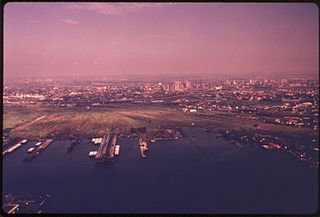
UPPER NEW YORK BAY AT JERSEY CITY, NEW JERSEY. LANDS ADJACENT TO THE BIGHT, RIVERS FLOWING INTO IT, AND BAYS AND ESTUARIES EDGING IT HAVE DIRECT IMPACT UPON THE ENVIRONMENT OF THE COASTAL WATERS. THE NEW YORK, NEW JERSEY METROPOLITAN REGION IS ONE OF THE MOST CONGESTED URBAN AND INDUSTRIAL AREAS IN THE WORLD |
||||||||||||||||||||||||||
| Depicted place |
Jersey City (Hudson county, New Jersey, United States, North and Central America) inhabited place (40°43′01″N 74°04′01″W / 40.717°N 74.067°W; NARA geographical record) |
||||||||||||||||||||||||||
| Date | June 1974 | ||||||||||||||||||||||||||
| Collection |
|
||||||||||||||||||||||||||
| Record ID |
NAIL Control Number: NWDNS-412-DA-13316
|
||||||||||||||||||||||||||
| Source | U.S. National Archives and Records Administration | ||||||||||||||||||||||||||
| Other versions |
Please do not overwrite this file: any restoration work should be uploaded with a new name and linked in this page's "other versions=" parameter, so that this file represents the exact file found in the NARA catalog record to which it links. The metadata on this page was imported directly from NARA's catalog record; additional descriptive text may be added by Wikimedians to the template below with the "description=" parameter, but please do not modify the other fields.
|
||||||||||||||||||||||||||


Licensing
edit
This file was provided to Wikimedia Commons by the National Archives and Records Administration as part of a cooperation project. The National Archives and Records Administration provides images depicting American and global history which are public domain or licensed under a free license.
|
This image (or other media) is a work of an Environmental Protection Agency employee, taken or made as part of that person's official duties. As works of the U.S. federal government, all EPA images are in the public domain.
|
||
File history
Click on a date/time to view the file as it appeared at that time.
| Date/Time | Thumbnail | Dimensions | User | Comment | |
|---|---|---|---|---|---|
| current | 01:59, 8 October 2011 | | 3,000 × 2,033 (935 KB) | US National Archives bot (talk | contribs) | == {{int:filedesc}} == {{NARA-image-full | Title = UPPER NEW YORK BAY AT JERSEY CITY, NEW JERSEY. LANDS ADJACENT TO THE BIGHT, RIVERS FLOWING INTO IT, AND BAYS AND ESTUARIES EDGING IT HAVE DIRECT IMPACT UPON THE ENVIRONMENT OF THE COAS |
You cannot overwrite this file.
File usage on Commons
The following 2 pages use this file: