File:URN NBN no-nb digifoto AE2000078779 0184 F 01 Brannposten i Drammen.jpg

Size of this preview: 800 × 496 pixels. Other resolutions: 320 × 198 pixels | 640 × 397 pixels | 1,024 × 635 pixels | 1,280 × 794 pixels | 2,963 × 1,837 pixels.
Original file (2,963 × 1,837 pixels, file size: 937 KB, MIME type: image/jpeg)
Captions
Captions
Add a one-line explanation of what this file represents
Summary
edit
| Description |
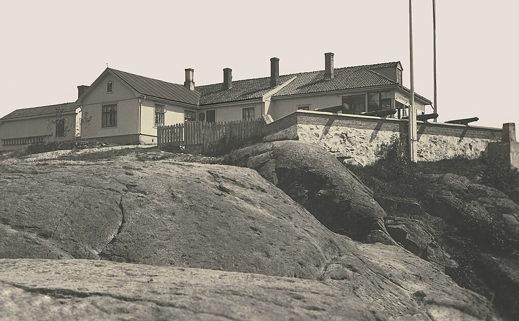
Norsk bokmål: Type: Postkort fra Drammen kommune
Dato: 1900 til 1970 Lisens: https://www.nb.no/lisens/publicdomain Andre opplysninger: Det gamle brannvarslingshus med kanoner som i 1817 ble bygget ved Bergstien til erstatning for en brannpost bygget i 1816, men som viste seg å ha for dårlig beliggenhet. Denne var igjen blitt bygget til avløsning av de gamle brannmeldeposter i tårnet på Bragernes kirke. Siste gang det ble varslet brann fra Brannposten var sommeren 1912 da Grønvold Brug og Høvleri gikk opp i flammer. Offisielt ble Brannposten først nedlagt i 1954. Foran vakthuset står fire brannkanoner innkjøpt fra Armédepartementet, den første i 1817, de øvrige i 1835 (en kanon som ble satt opp i 1816 var utlånt av kjøpmann Niels Omsted og ble tilbakelevert ham i 1835). Opprinnelig ble det avfyrt ett skudd hvis det ble oppdaget brann før kl. 21. Ble brannen oppdaget etter kl. 21, ble det avfyrt to skudd, hvis ilden var på Strømsø eller Tangen, tre skudd hvis brannen var på Bragernes. Anlegget er fredet, og huser i 2022 Brannposten naturbarnehage. |
| Date | |
| Source | https://urn.nb.no/URN:NBN:no-nb_digifoto_AE2000078779_0184 |
| Author | ukjent fotograf |
| Object location | | View this and other nearby images on: OpenStreetMap |
|---|
Licensing
edit
| This file is made available under the Creative Commons CC0 1.0 Universal Public Domain Dedication. | |
| The person who associated a work with this deed has dedicated the work to the public domain by waiving all of their rights to the work worldwide under copyright law, including all related and neighboring rights, to the extent allowed by law. You can copy, modify, distribute and perform the work, even for commercial purposes, all without asking permission.
|
File history
Click on a date/time to view the file as it appeared at that time.
| Date/Time | Thumbnail | Dimensions | User | Comment | |
|---|---|---|---|---|---|
| current | 01:30, 3 March 2023 | | 2,963 × 1,837 (937 KB) | TigerfraMars (talk | contribs) | Uploaded a work by ukjent fotograf from https://urn.nb.no/URN:NBN:no-nb_digifoto_AE2000078779_0184 with UploadWizard |
You cannot overwrite this file.
File usage on Commons
There are no pages that use this file.
File usage on other wikis
The following other wikis use this file:
- Usage on no.wikipedia.org