File:US26Beaverton2.jpg

Size of this preview: 800 × 600 pixels. Other resolutions: 320 × 240 pixels | 640 × 480 pixels | 1,024 × 768 pixels.
Original file (1,024 × 768 pixels, file size: 318 KB, MIME type: image/jpeg)
Captions
Captions
Add a one-line explanation of what this file represents
Summary
edit
| Description |
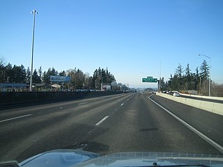
English: U.S. Route 26 (Sunset Highway) in Beaverton, Oregon on January 14, 2007. The slip road at right is traffic from northbound Oregon Route 217 merging with US 26 westbound. Traffic from OR 217 north crosses over the Cedar Hills Boulevard exit before merging, thus eliminating a dangerous weaving conflict. |
| Date | 17 January 2007 (original upload date) |
| Source | Transferred from en.wikipedia by SreeBot |
| Author | Deloreanman14 at en.wikipedia |
Licensing
edit
Deloreanman14 at the English-language Wikipedia, the copyright holder of this work, hereby publishes it under the following license:
| This file is licensed under the Creative Commons Attribution-Share Alike 3.0 Unported license. Subject to disclaimers. | ||
| Attribution: Deloreanman14 at the English-language Wikipedia | ||
| ||
| This licensing tag was added to this file as part of the GFDL licensing update. |

|
Permission is granted to copy, distribute and/or modify this document under the terms of the GNU Free Documentation License, Version 1.2 or any later version published by the Free Software Foundation; with no Invariant Sections, no Front-Cover Texts, and no Back-Cover Texts. A copy of the license is included in the section entitled GNU Free Documentation License. Subject to disclaimers. |
Original upload log
edit
The original description page was here. All following user names refer to en.wikipedia.
Upload date | User | Bytes | Dimensions | Comment
- 2007-01-17 08:10 (UTC) | Deloreanman14 | 325542 (bytes) | 1024×768 | US-26 at the Cedar Hills Boulevard/Beaverton exit just west of Portland. Traffic from Highway 217 can be seen paralleling on the right and crosses over the Cedar Hills off-ramp to merge with US-26.
- 2007-01-17 08:08 (UTC) | Deloreanman14 | 306992 (bytes) | 1024×768 | US Highway 26 (Sunset Highway) in Beaverton, Oregon on January 14, 2007.
File history
Click on a date/time to view the file as it appeared at that time.
| Date/Time | Thumbnail | Dimensions | User | Comment | |
|---|---|---|---|---|---|
| current | 10:34, 12 October 2011 | | 1,024 × 768 (318 KB) | SreeBot (talk | contribs) | (Original text) : US-26 at the Cedar Hills Boulevard/Beaverton exit just west of Portland. Traffic from Highway 217 can be seen paralleling on the right and crosses over the Cedar Hills off-ramp to merge with US-26. |
| 10:34, 12 October 2011 |  | 1,024 × 768 (300 KB) | SreeBot (talk | contribs) | (Original text) : US Highway 26 (Sunset Highway) in Beaverton, Oregon on January 14, 2007. |
You cannot overwrite this file.
File usage on Commons
There are no pages that use this file.