File:USGS Bulletin787 Plate5 FigureA Cranktown Sandstone and rhyolite tuff.jpg

Original file (1,064 × 1,284 pixels, file size: 612 KB, MIME type: image/jpeg)
Captions
Captions
Summary
edit
| Description |
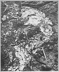
English: Original caption: Cranktown Sandstone, showing cross-bedding, with interbedded lens of rhyolite tuff Uploader note: The captions of Figures A and B of Plate 5 of this publication are apparently reversed and this caption is correct for the photo. The text of the report states: After the deposition of the Cooney quartz latite and tuffs there was a period of erosion in which deep canyons were cut and a probably very rugged topography developed. Later the steep-sided valleys were rilled with sandstone containing lenses of conglomerate, here named the Cranktown sandstone, from the name commonly applied to a small group of prospectors' cabins on Silver Creek about a mile below Mogollon. Remnants of the old canyons are now revealed on the walls of Gold Dust Gulch and Houston Canyon. As shown in Houston Canyon a steep-sided gorge more than 100 feet in depth was cut in the Cooney quartz latite and later filled with sandstone. Plate 5, A, shows a portion of such a canyon. Here the wall was in part overhanging, so that the older Cooney quartz latite appears to overlie the younger sandstone. The Cranktown sandstone is confined to the western part of the area, and owing to the irregular topography at the time of its deposition it varies greatly in thickness from place to place. The maximum observed thickness is 500 feet, near the mouth of Silver Creek. In Houston Canyon the exposed thickness exceeds 400 feet. At the edge of the buried canyon referred to above the thickness changes from 200 feet to about 20 feet within a horizontal distance of less than 300 feet, and 200 feet farther to the east the sandstone disappears altogether. It is lacking in the deep workings of the Fanney mine, which penetrate the Cooney quartz latite. Similarly it thins toward the south, as it was not found in the canyon of Whitewater Creek. The formation is about 100 feet thick on Silver Peak, near the northern edge of the area mapped. Here also it decreases in thickness eastward, though the change is not so abrupt as in Gold Dust Gulch. The sandstone is commonly red to deep purple, and nearly everywhere shows cross-bedding. It is commonly rather fine grained and largely composed of small fragments of feldspar, for the most part angular. A little biotite is also present. Here and there the fine-grained beds contain pebbles of rhyolite and andesite. The conglomeratic lenses are rather rare and do not extend for long distances. Near Cooney there is, however, a thick bed of very coarse conglomerate containing angular boulders, the largest of which exceed 3 feet in width. (pl. 6, A.) The irregular dips that characterize the Cranktown sandstone are, in large part at least, due to the initial angle of deposition. For instance, in the north wall of Mineral Creek Canyon, opposite the Cooney mine, the sandstone, which dips 5°-30° to the east and northeast, overlies the Cooney quartz latite, which here dips 10°-15° NW., and is itself overlain by andesite tuffs with sandstone beds that show easterly dips of 5°-8°. The deposition of the sandstone was thrice interrupted by volcanic activity, resulting in a flow of andesite, a bed of rhyolite tuff, and several flows of rhyolite. The andesite flow, near the base, and the rhyolite flows, near the top, have been mapped separately and are described below. The rhyolite tuff (pl. 5, B.) occurs in the upper part a short distance below the massive rhyolite flows. Its maximum thickness is about 25 feet, and it is not everywhere present. This band of white tuff shows in striking contrast to the purple sandstone above and below, and in the walls of the Silver Creek Canyon, north of the Pacific mine, it is traceable for a distance of 2,000 feet. At the western end it is cut out by the overlying Pacific quartz latite, which here occupies a valley cut in the sandstone. To the east it dips below the creek bed. Tuff of a similar type, possibly the same bed, was seen on the west wall of Houston Canyon, close to the western border of the area mapped. The tuff is white to gray or pink and usually very fine grained, though here and there it contains small pebbles of rhyolite that closely resembles the overlying Pacific quartz latite. The principal components are small angular grains of quartz and sericitized feldspar, with small patches of chlorite probably representing original biotite. The upper portion of the sandstone overlies the Pacific quartz latite and contains much material derived from that rock. As the Pacific quartz latite is lacking in the southern part of the area the two portions of the sandstone could not be separately mapped. In the north branch of Houston Canyon, just under the Silver City road, a conglomerate containing pebbles derived from the Pacific quartz latite as well as from the Cooney quartz latite shows that here the sandstone is younger than both. |
| Date | |
| Source | Geology and Ore Deposits of the Mogollon Mining District, New Mexico. United States Geological Survey Bulletin 787. Washington Government Printing Office, 1927. |
| Author | Henry G. Ferguson |
Licensing
edit
This work is in the public domain in the United States because it is a work prepared by an officer or employee of the United States Government as part of that person’s official duties under the terms of Title 17, Chapter 1, Section 105 of the US Code.
Note: This only applies to original works of the Federal Government and not to the work of any individual U.S. state, territory, commonwealth, county, municipality, or any other subdivision. This template also does not apply to postage stamp designs published by the United States Postal Service since 1978. (See § 313.6(C)(1) of Compendium of U.S. Copyright Office Practices). It also does not apply to certain US coins; see The US Mint Terms of Use.
|
 | |
| This file has been identified as being free of known restrictions under copyright law, including all related and neighboring rights. | ||
File history
Click on a date/time to view the file as it appeared at that time.
| Date/Time | Thumbnail | Dimensions | User | Comment | |
|---|---|---|---|---|---|
| current | 15:49, 11 December 2019 | | 1,064 × 1,284 (612 KB) | Jstuby (talk | contribs) | User created page with UploadWizard |
You cannot overwrite this file.
File usage on Commons
There are no pages that use this file.