File:USGS Geologic Map of the Lisbon Valley uranium mines.png

Size of this preview: 800 × 403 pixels. Other resolutions: 320 × 161 pixels | 640 × 323 pixels | 1,103 × 556 pixels.
Original file (1,103 × 556 pixels, file size: 1.53 MB, MIME type: image/png)
Captions
Captions
Add a one-line explanation of what this file represents
Summary edit
| Description |
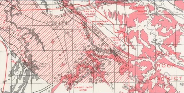
English: USGS Geologic map of the Lisbon Valley area with the Late Jurassic Morrison Formation shaded red, the Late Triassic Chinle Formation shaded black, vertical black hatching depicting the basal part of the Chinle Formation, red diagonal hatching depicting the Moss Back Member of the Chinle Formation, and key uranium mines numbered. The Mi Vida Mine is a red number 68. |
| Date | |
| Source | Uranium Deposits of the Moab, Monticello, White Canyon, and Monument Valley Districts, Utah and Arizona, USGS Bulletin 1222-H |
| Author | H.S. Johnson, Jr., and William Thordarson |
Licensing edit
This work is in the public domain in the United States because it is a work prepared by an officer or employee of the United States Government as part of that person’s official duties under the terms of Title 17, Chapter 1, Section 105 of the US Code.
Note: This only applies to original works of the Federal Government and not to the work of any individual U.S. state, territory, commonwealth, county, municipality, or any other subdivision. This template also does not apply to postage stamp designs published by the United States Postal Service since 1978. (See § 313.6(C)(1) of Compendium of U.S. Copyright Office Practices). It also does not apply to certain US coins; see The US Mint Terms of Use.
|
 | |
| This file has been identified as being free of known restrictions under copyright law, including all related and neighboring rights. | ||
File history
Click on a date/time to view the file as it appeared at that time.
| Date/Time | Thumbnail | Dimensions | User | Comment | |
|---|---|---|---|---|---|
| current | 15:12, 17 March 2017 | | 1,103 × 556 (1.53 MB) | Pi3.124 (talk | contribs) | User created page with UploadWizard |
You cannot overwrite this file.
File usage on Commons
There are no pages that use this file.
File usage on other wikis
The following other wikis use this file:
- Usage on en.wikipedia.org