File:USGS Map 6.3mb North Korea Explosion Nuclear.jpg

Size of this preview: 536 × 599 pixels. Other resolutions: 215 × 240 pixels | 612 × 684 pixels.
Original file (612 × 684 pixels, file size: 98 KB, MIME type: image/jpeg)
Captions
Captions
Add a one-line explanation of what this file represents
Summary
edit
| Description |
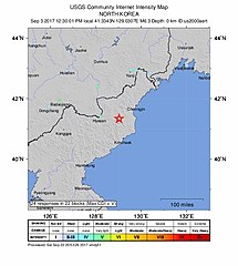
English: USGS Map 6.3mb North Knorea Explosion Nuclear |
| Date | |
| Source | https://earthquake.usgs.gov/earthquakes/eventpage/us2000aert/dyfi/intensity |
| Author | United States Geology Survey |
Licensing
edit
This image is in the public domain in the United States because it only contains materials that originally came from the United States Geological Survey, an agency of the United States Department of the Interior. For more information, see the official USGS copyright policy.
|
File history
Click on a date/time to view the file as it appeared at that time.
| Date/Time | Thumbnail | Dimensions | User | Comment | |
|---|---|---|---|---|---|
| current | 00:09, 28 February 2020 | | 612 × 684 (98 KB) | Dimentio 地震 (talk | contribs) | User created page with UploadWizard |
You cannot overwrite this file.
File usage on Commons
There are no pages that use this file.