File:USGS ShakeMap 2008uva4.jpg

Size of this preview: 512 × 599 pixels. Other resolutions: 205 × 240 pixels | 612 × 716 pixels.
Original file (612 × 716 pixels, file size: 88 KB, MIME type: image/jpeg)
Captions
Captions
Add a one-line explanation of what this file represents
Summary
edit
| Description |
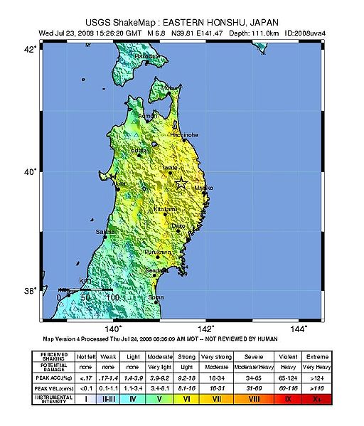
USGS ShakeMap : EASTERN HONSHU, JAPAN Wed Jul 23, 2008 15:26:20 GMT M 6.8 N39.79 E141.43 Depth: 111.7km ID:2008uva4 Map Version 1 Processed Wed Jul 23, 2008 09:48:41 AM MDT -- NOT REVIEWED BY HUMAN |
| Date | Jul 23, 2008 (UTC) |
| Source | https://earthquake.usgs.gov/eqcenter/shakemap/global/shake/2008uva4/ |
| Author | USGS |
Licensing
edit
This image is in the public domain in the United States because it only contains materials that originally came from the United States Geological Survey, an agency of the United States Department of the Interior. For more information, see the official USGS copyright policy.
|
File history
Click on a date/time to view the file as it appeared at that time.
| Date/Time | Thumbnail | Dimensions | User | Comment | |
|---|---|---|---|---|---|
| current | 16:06, 24 July 2008 | | 612 × 716 (88 KB) | 新鳩244号 (talk | contribs) | USGS ShakeMap : EASTERN HONSHU, JAPAN<br />Wed Jul 23, 2008 15:26:20 GMT M 6.8 N39.81 E141.47 Depth: 111.0km ID:2008uva4<br />Map Version 4 Processed Thu Jul 24, 2008 08:36:09 AM MDT -- NOT REVIEWED BY HUMAN Category:Earthquakes of 2008 |
| 06:38, 24 July 2008 |  | 612 × 716 (87 KB) | 新鳩244号 (talk | contribs) | USGS ShakeMap : EASTERN HONSHU, JAPAN<br />Wed Jul 23, 2008 15:26:20 GMT M 6.8 N39.81 E141.47 Depth: 111.0km ID:2008uva4<br />Map Version 3 Processed Wed Jul 23, 2008 02:00:30 PM MDT -- NOT REVIEWED BY HUMAN Category:Earthquakes of 2008 | |
| 16:49, 23 July 2008 |  | 612 × 716 (88 KB) | 新鳩244号 (talk | contribs) | {{Information |Description=USGS ShakeMap : EASTERN HONSHU, JAPAN<br />Wed Jul 23, 2008 15:26:20 GMT M 6.8 N39.79 E141.43 Depth: 111.7km ID:2008uva4<br />Map Version 1 Processed Wed Jul 23, 2008 09:48:41 AM MDT -- NOT REVIEWED BY HUMAN |Source=http |
You cannot overwrite this file.
File usage on Commons
There are no pages that use this file.
File usage on other wikis
The following other wikis use this file:
- Usage on en.wikipedia.org
- Usage on it.wikinews.org
- Usage on ja.wikipedia.org
- Usage on ko.wikipedia.org
- Usage on vi.wikipedia.org
- Usage on zh.wikipedia.org