File:USintercityrailfrequencymap may1971.svg

Size of this PNG preview of this SVG file: 800 × 495 pixels. Other resolutions: 320 × 198 pixels | 640 × 396 pixels | 1,024 × 633 pixels | 1,280 × 791 pixels | 2,560 × 1,583 pixels | 959 × 593 pixels.
Original file (SVG file, nominally 959 × 593 pixels, file size: 219 KB)
Captions
Captions
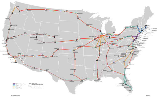
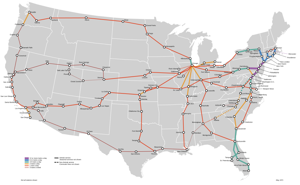
Map of intercity passenger rail in the contiguous United States at the end of May 1971 (the month of Amtrak's formation) showing service type and frequency by color and line thickness
Summary
edit
| Description |
English: Map of intercity passenger rail in the contiguous United States at the end of May 1971 (the month of Amtrak's formation) showing service type and frequency by color and line thickness |
| Date | |
| Source | Own work |
| Author | Blank_US_Map.svg by User:Theshibboleth; Eldomtom2 |
Licensing
edit
I, the copyright holder of this work, hereby publish it under the following license:
This file is licensed under the Creative Commons Attribution-Share Alike 4.0 International license.
- You are free:
- to share – to copy, distribute and transmit the work
- to remix – to adapt the work
- Under the following conditions:
- attribution – You must give appropriate credit, provide a link to the license, and indicate if changes were made. You may do so in any reasonable manner, but not in any way that suggests the licensor endorses you or your use.
- share alike – If you remix, transform, or build upon the material, you must distribute your contributions under the same or compatible license as the original.
File history
Click on a date/time to view the file as it appeared at that time.
| Date/Time | Thumbnail | Dimensions | User | Comment | |
|---|---|---|---|---|---|
| current | 20:43, 23 May 2024 | | 959 × 593 (219 KB) | Eldomtom2 (talk | contribs) | Uploaded own work with UploadWizard |
You cannot overwrite this file.
File usage on Commons
The following 4 pages use this file: