File:UTMap-doton-Kaiparowits.png
No higher resolution available.
UTMap-doton-Kaiparowits.png (153 × 200 pixels, file size: 1 KB, MIME type: image/png)
Captions
Captions
Add a one-line explanation of what this file represents
Summary
edit
| Description | |
| Date | 10 October 2007 (original upload date) |
| Source | Transferred from en.wikipedia |
| Author | Original uploader was G. Thomas at en.wikipedia |
| Permission (Reusing this file) |
Released into the public domain (by the author). |
Licensing
edit
| |
This work has been released into the public domain by its author, G. Thomas, at the English Wikipedia project. This applies worldwide. In case this is not legally possible: |
Original upload log
edit
The original description page was here. All following user names refer to en.wikipedia.
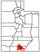
- 2007-10-10 19:58 G. Thomas 153×200× (1208 bytes) Location of the [[Kaiparowits Plateau]] within [[Utah]].
Licensing
edit
| I, the copyright holder of this work, release this work into the public domain. This applies worldwide. In some countries this may not be legally possible; if so: I grant anyone the right to use this work for any purpose, without any conditions, unless such conditions are required by law. |
File history
Click on a date/time to view the file as it appeared at that time.
| Date/Time | Thumbnail | Dimensions | User | Comment | |
|---|---|---|---|---|---|
| current | 20:47, 14 March 2009 | | 153 × 200 (1 KB) | Sylfred1977 (talk | contribs) | {{Information |Description={{en|Location of the en:Kaiparowits Plateau within en:Utah.}} |Source=Transferred from [http://en.wikipedia.org en.wikipedia] |Date=2007-10-10 (original upload date) |Author=Original uploader was [[:en:User:G. Thomas|G |
You cannot overwrite this file.
File usage on Commons
There are no pages that use this file.
File usage on other wikis
The following other wikis use this file:
- Usage on en.wikipedia.org
- Usage on fr.wikipedia.org