File:U oběšeného, CZ170611-011.jpg
![File:U oběšeného, CZ170611-011.jpg](https://upload.wikimedia.org/wikipedia/commons/thumb/4/44/U_ob%C4%9B%C5%A1en%C3%A9ho%2C_CZ170611-011.jpg/800px-U_ob%C4%9B%C5%A1en%C3%A9ho%2C_CZ170611-011.jpg?20180419120740)
Original file (4,575 × 2,674 pixels, file size: 3.05 MB, MIME type: image/jpeg)
Captions
Captions
Summary
editDescriptionU oběšeného, CZ170611-011.jpg |
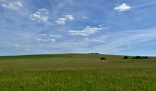
English: "U oběšeného" is czech geographic name of hill with an altitude of 737.4 m on the edge of the Iron Mountains. A view of the top from the north. Below the peak on damp meadows part of the springfield of the river with name "Krounka" (see shrubs on the photo). Below are natural habitats with peat bog and fens (also in the natural monument with name "U Tučkovy hájenky"). Flowering meadows at the beginning of summer. Locality of "Kameničská" highlands in the Protected Landscape Area "Žďárské" hills. Within the regional division of the Czech Republic's georelief lies the highest peak of the Iron Mountains in the southeast part of the mountain range with called Sečská vrchovina, in the geomorphological district Kameničská vrchovina. The hill is located in the cadastral area Svratouch in the Chrudim District, belong to the Pardubice Region in the Czech Republic. Photo-location: Czechia, Pardubice Region, the village of "Svratouch".
Čeština: U oběšeného je zeměpisný název kopce s nadmořskou výškou 737,4 m na okraji pohoří Železných hor. Pohled k vrcholu od severu. Pod vrcholem na vlhkých loukách část prameniště řeky Krounky (viz keře na fotografii). V polohách níže přírodní stanoviště s rašeliništěm a slatiništěm (také v přírodní památce U Tučkovy hájenky). Kvetoucí louky počátkem léta. Lokalita Kameničské vrchoviny v Chráněné krajinné oblasti Žďárské vrchy. V rámci regionálního členění georeliéfu Česka leží nejvyšší vrchol Železných hor v jihovýchodní části pohoří nazvané Sečská vrchovina, v geomorfologickém okrsku Kameničská vrchovina. Kopec se nachází na katastrálním území Svratouch v okrese Chrudim náležejícím do Pardubického kraje v České republice. Foto-lokace: Česko, Pardubický kraj, obec Svratouch (180°). |
Date | |
Source | Own work |
Author | Josef Kreuz (PEPan) |
Camera location | 49° 44′ 12.65″ N, 16° 01′ 09.13″ E ![]() ![]() | View this and other nearby images on: OpenStreetMap | ![]() |
---|
Licensing
edit![w:en:Creative Commons](https://upload.wikimedia.org/wikipedia/commons/thumb/7/79/CC_some_rights_reserved.svg/90px-CC_some_rights_reserved.svg.png)
![attribution](https://upload.wikimedia.org/wikipedia/commons/thumb/1/11/Cc-by_new_white.svg/24px-Cc-by_new_white.svg.png)
![share alike](https://upload.wikimedia.org/wikipedia/commons/thumb/d/df/Cc-sa_white.svg/24px-Cc-sa_white.svg.png)
- You are free:
- to share – to copy, distribute and transmit the work
- to remix – to adapt the work
- Under the following conditions:
- attribution – You must give appropriate credit, provide a link to the license, and indicate if changes were made. You may do so in any reasonable manner, but not in any way that suggests the licensor endorses you or your use.
- share alike – If you remix, transform, or build upon the material, you must distribute your contributions under the same or compatible license as the original.
File history
Click on a date/time to view the file as it appeared at that time.
Date/Time | Thumbnail | Dimensions | User | Comment | |
---|---|---|---|---|---|
current | 12:07, 19 April 2018 | ![]() | 4,575 × 2,674 (3.05 MB) | PEPan (talk | contribs) | User created page with UploadWizard |
You cannot overwrite this file.
File usage on Commons
There are no pages that use this file.
File usage on other wikis
The following other wikis use this file:
- Usage on cs.wikipedia.org
Metadata
This file contains additional information such as Exif metadata which may have been added by the digital camera, scanner, or software program used to create or digitize it. If the file has been modified from its original state, some details such as the timestamp may not fully reflect those of the original file. The timestamp is only as accurate as the clock in the camera, and it may be completely wrong.
Camera manufacturer | Panasonic |
---|---|
Camera model | DMC-TZ60 |
Author | Josef Kreuz |
Copyright holder |
|
Exposure time | 1/1,600 sec (0.000625) |
F-number | f/3.3 |
ISO speed rating | 100 |
Date and time of data generation | 17:01, 11 June 2017 |
Lens focal length | 4.3 mm |
User comments | EN: "U oběšeného" is czech geographic name of hill with an altitude of 737.4 m on the edge of the Iron Mountains. A view of the top from the north. Below the peak on damp meadows part of the springfield of the river with name "Krounka" (see shrubs on the photo). Below are natural habitats with peat bog and fens (also in the natural monument with name "U Tučkovy hájenky"). Flowering meadows at the beginning of summer. Locality of "Kameničská" highlands in the Protected Landscape Area "Žďárské" hills. Within the regional division of the Czech Republic's georelief lies the highest peak of the Iron Mountains in the southeast part of the mountain range with called Sečská vrchovina, in the geomorphological district Kameničská vrchovina. The hill is located in the cadastral area Svratouch in the Chrudim District, belong to the Pardubice Region in the Czech Republic. Photo-location: Czechia, Pardubice Region, the village of "Svratouch".
CZ: U oběšeného je zeměpisný název kopce s nadmořskou výškou 737,4 m na okraji pohoří Železných hor. Pohled k vrcholu od severu. Pod vrcholem na vlhkých loukách část prameniště řeky Krounky (viz keře na fotografii). V polohách níže přírodní stanoviště s rašeliništěm a slatiništěm (také v přírodní památce U Tučkovy hájenky). Kvetoucí louky počátkem léta. Lokalita Kameničské vrchoviny v Chráněné krajinné oblasti Žďárské vrchy. V rámci regionálního členění georeliéfu Česka je nejvyšším vrcholem Železných hor v jihovýchodní části pohoří nazvané Sečská vrchovina, v geomorfologickém okrsku Kameničská vrchovina. Kopec se nachází na katastrálním území Svratouch v okrese Chrudim náležejícím do Pardubického kraje v České republice. Foto-lokace: Česko, Pardubický kraj, obec Svratouch (180°). Keywords: Svratouch;U oběšeného;prameniště řeky Krounky;louky |
Latitude | 49° 44′ 12.64″ N |
Longitude | 16° 1′ 9.13″ E |
Short title |
|
Image title |
|
Label | Yellow |
City shown | Svratouch |
Compression scheme | Uncompressed |
Pixel composition | RGB |
Orientation | Normal |
Horizontal resolution | 180 dpi |
Vertical resolution | 180 dpi |
Data arrangement | chunky format |
Software used | Zoner Photo Studio 18 |
File change date and time | 14:05, 19 April 2018 |
Y and C positioning | Centered |
Exposure Program | Normal program |
Exif version | 2.3 |
Date and time of digitizing | 17:01, 11 June 2017 |
Meaning of each component |
|
Image compression mode | 4 |
APEX exposure bias | 0 |
Maximum land aperture | 3.4453125 APEX (f/3.3) |
Metering mode | Pattern |
Light source | Unknown |
Flash | Flash did not fire, compulsory flash suppression |
Supported Flashpix version | 1 |
Color space | sRGB |
Sensing method | One-chip color area sensor |
File source | Digital still camera |
Scene type | A directly photographed image |
Custom image processing | Normal process |
Exposure mode | Auto exposure |
White balance | Auto white balance |
Digital zoom ratio | 0 |
Focal length in 35 mm film | 27 mm |
Scene capture type | Standard |
Scene control | None |
Contrast | Normal |
Saturation | Normal |
Sharpness | Normal |
GPS time (atomic clock) | 15:00 |
Receiver status | Measurement in progress |
Measurement mode | 2-dimensional measurement |
Measurement precision | Fair (1.2) |
Geodetic survey data used | WGS-84 |
Name of GPS area | ⴀⴀⴀ |
GPS date | 11 June 2017 |
GPS tag version | 0.0.3.2 |
Keywords |
|
Writer | Josef Kreuz |
Province or state shown | Pardubický kraj |
Country shown | Česko |
Code for country shown | CZ |
Sublocation of city shown | U oběšeného |