File:Ugarit mapa.jpg
No higher resolution available.
Ugarit_mapa.jpg (239 × 260 pixels, file size: 76 KB, MIME type: image/jpeg)
Captions
Captions
Add a one-line explanation of what this file represents
Summary edit
| Description |
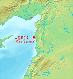
Čeština: Mapa syrské archeologické lokality Ugarit (dnešní Ras Šamra).
Při úpravě mapy byl použit software DEMIS World Map Server. English: Map of the Syrian archaeological site of Ugarit (today's Ras Shamra).
Software was used to edit the map World Map Server. |
| Date | 8 April 2005 (original upload date) |
| Source | Transferred from cs.wikipedia to Commons. |
| Author | Ansgar at Czech Wikipedia |
Licensing edit
| This work has been released into the public domain by its author, Ansgar at Czech Wikipedia. This applies worldwide. In some countries this may not be legally possible; if so: Ansgar grants anyone the right to use this work for any purpose, without any conditions, unless such conditions are required by law. |
Original upload log edit
The original description page was here. All following user names refer to cs.wikipedia.
- 2005-04-08 23:27 Ansgar 239×260× (78010 bytes) Mapa syrské archeologické lokality Ugarit (dnešní Ras Šamra). {{PD-self}} Při úpravě mapy byl použit software [http://www2.demis.nl/ DEMIS World Map Server].
- 2005-03-25 21:58 Ansgar 149×289× (13636 bytes) Mapa s vyznačením Ugaritu. Autorem úprav na mapě je [[Wikipedista:Ansgar|Ansgar]].
File history
Click on a date/time to view the file as it appeared at that time.
| Date/Time | Thumbnail | Dimensions | User | Comment | |
|---|---|---|---|---|---|
| current | 10:40, 19 January 2010 | | 239 × 260 (76 KB) | Harold (talk | contribs) | == {{int:filedesc}} == {{Information |Description={{cs|Mapa syrské archeologické lokality Ugarit (dnešní Ras Šamra). Při úpravě mapy byl použit software [http://www2.demis.nl/ DEMIS World Map Server].}} |Source=Transferred from [http://cs.wikip |
You cannot overwrite this file.
File usage on Commons
There are no pages that use this file.
File usage on other wikis
The following other wikis use this file:
- Usage on ba.wikipedia.org
- Usage on ca.wikipedia.org
- Usage on cs.wikipedia.org
- Usage on de.wikipedia.org
- Usage on en.wikipedia.org
- Usage on es.wikipedia.org
- Usage on fr.wiktionary.org
- Usage on hu.wikipedia.org
- Usage on ja.wikipedia.org
- Usage on pl.wikipedia.org
- Usage on pt.wikipedia.org
- Usage on sk.wikipedia.org
- Usage on tr.wikipedia.org
- Usage on uk.wikipedia.org
- Usage on zh.wikipedia.org