File:Uinta Piceance Basin stratigraphic column.png
No higher resolution available.
Uinta_Piceance_Basin_stratigraphic_column.png (531 × 544 pixels, file size: 59 KB, MIME type: image/png)
Captions
Captions
Add a one-line explanation of what this file represents
Summary edit
| Description |
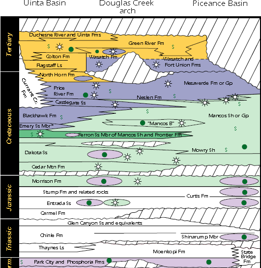
English: Uinta Piceance Basin stratigraphic column. Orange is the Green River System, dark purple is the Mesaverde System, dark green is the Ferron/Wasatch Plateau System, light green is the Mancos/Mowry System, and light purple is the Phosphoria System. Green circles represent significant oil production, open star-circles represent significant gas production, and "S"s represent source rocks. |
| Date | |
| Source | The Uinta-Piceance Province - Introduction to a geologic assessment of undiscovered oil and gas resources, USGS Digital Data Series DDS-69-B, page 8 |
| Author | USGS Uinta-Piceance Assessment Team |
| Other versions | higher-resolution gif version with wider crop |
Licensing edit
This work is in the public domain in the United States because it is a work prepared by an officer or employee of the United States Government as part of that person’s official duties under the terms of Title 17, Chapter 1, Section 105 of the US Code.
Note: This only applies to original works of the Federal Government and not to the work of any individual U.S. state, territory, commonwealth, county, municipality, or any other subdivision. This template also does not apply to postage stamp designs published by the United States Postal Service since 1978. (See § 313.6(C)(1) of Compendium of U.S. Copyright Office Practices). It also does not apply to certain US coins; see The US Mint Terms of Use.
|
 | |
| This file has been identified as being free of known restrictions under copyright law, including all related and neighboring rights. | ||
File history
Click on a date/time to view the file as it appeared at that time.
| Date/Time | Thumbnail | Dimensions | User | Comment | |
|---|---|---|---|---|---|
| current | 11:48, 2 June 2017 | | 531 × 544 (59 KB) | Pi3.124 (talk | contribs) | User created page with UploadWizard |
You cannot overwrite this file.
File usage on Commons
There are no pages that use this file.
File usage on other wikis
The following other wikis use this file:
- Usage on en.wikiversity.org