File:Ukrainian Railways (subdivisions).png
Size of this preview: 800 × 549 pixels. Other resolutions: 320 × 220 pixels | 640 × 439 pixels | 1,024 × 702 pixels | 1,280 × 878 pixels | 1,500 × 1,029 pixels.
Original file (1,500 × 1,029 pixels, file size: 359 KB, MIME type: image/png)
Captions
Captions
Add a one-line explanation of what this file represents

|
This transport map image could be re-created using vector graphics as an SVG file. This has several advantages; see Commons:Media for cleanup for more information. If an SVG form of this image is available, please upload it and afterwards replace this template with
{{vector version available|new image name}}.
It is recommended to name the SVG file “Ukrainian Railways (subdivisions).svg”—then the template Vector version available (or Vva) does not need the new image name parameter. |
Summary
edit.png&action=edit§ion=1)
| Description |
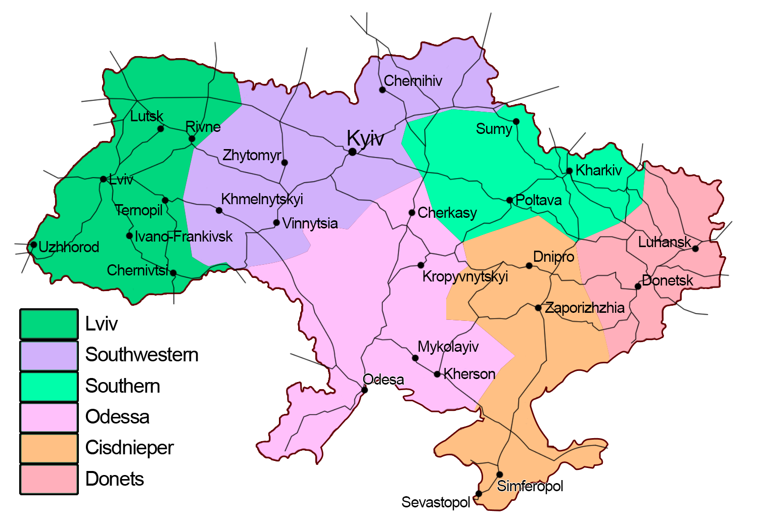
English: Subdivisions of Ukrainian Railways. Українська: Територіальний поділ залізниць України (англійською мовою). |
| Date | |
| Source | Own work |
| Author | Terek |
Licensing
edit.png&action=edit§ion=2)
I, the copyright holder of this work, hereby publish it under the following license:
This file is licensed under the Creative Commons Attribution-Share Alike 4.0 International license.
- You are free:
- to share – to copy, distribute and transmit the work
- to remix – to adapt the work
- Under the following conditions:
- attribution – You must give appropriate credit, provide a link to the license, and indicate if changes were made. You may do so in any reasonable manner, but not in any way that suggests the licensor endorses you or your use.
- share alike – If you remix, transform, or build upon the material, you must distribute your contributions under the same or compatible license as the original.
File history
Click on a date/time to view the file as it appeared at that time.
| Date/Time | Thumbnail | Dimensions | User | Comment | |
|---|---|---|---|---|---|
| current | 22:42, 6 July 2020 | | 1,500 × 1,029 (359 KB) | Terek (talk | contribs) | Near-Drnipro -> Cisdnieper |
| 19:17, 19 August 2016 |  | 1,500 × 1,029 (357 KB) | Terek (talk | contribs) | renamed cities changed | |
| 13:28, 29 July 2014 |  | 1,500 × 1,029 (353 KB) | Terek (talk | contribs) | railway network added; ukr. border improved; other borders removed | |
| 16:50, 28 July 2014 |  | 1,500 × 1,029 (333 KB) | Terek (talk | contribs) | User created page with UploadWizard |
You cannot overwrite this file.
File usage on Commons
The following 9 pages use this file:
- Top 200 map images that should use vector graphics
- Top 200 transport map images that should use vector graphics
- User:Chumwa/OgreBot/Potential transport maps/2016 August 11-20
- User:Chumwa/OgreBot/Public transport information/2016 August 11-20
- User:Chumwa/OgreBot/Public transport information/2020 July 1-10
- User:Chumwa/OgreBot/Transport Maps/2016 August 11-20
- User:Chumwa/OgreBot/Transport Maps/2020 July 1-10
- User:Chumwa/OgreBot/Travel and communication maps/2016 August 11-20
- User:Magog the Ogre/Multilingual legend/2020 July 1-10
File usage on other wikis
The following other wikis use this file:
- Usage on bg.wikipedia.org
- Usage on de.wikipedia.org
- Usage on en.wikipedia.org
- Usage on eo.wikipedia.org
- Kruti (stacidomo)
- Kijiv-Pasaĵirskij (stacidomo)
- Ĥarkiv-Pasaĵirskij (stacidomo)
- Dnipro-Holovnij (stacidomo)
- Odesa-Holovna (stacidomo)
- Doneck (stacidomo)
- Zaporiĵĵja-1 (stacidomo)
- Lviv-Holovnij (stacidomo)
- Krivij Rih-Holovnij (stacidomo)
- Mikolajiv-Pasaĵirskij (stacidomo)
- Mariupol (stacidomo)
- Ĥerson (stacidomo)
- Vinnicja (stacidomo)
- Ivano-Frankivsk (stacidomo)
- Ĥmelnickij (stacidomo)
- Rivne (stacidomo)
- Luhansk (stacidomo)
- Poltava-Kijivska (stacidomo)
- Ĉernihiv (stacidomo)
- Listo de fervojaj stacioj en Ukrainio
- Horlivka (stacidomo)
- Ĵitomir (stacidomo)
- Makijivka-Pasaĵirska (stacidomo)
- Ĉerkaso (stacidomo)
- Sumi (stacidomo)
- Ŝablono:Ukrainaj fervojoj
- Kamjanske-Pasaĵirske (stacidomo)
- Kropivnickij (stacidomo)
- Ĉernivci (stacidomo)
- Kremenĉuk (stacidomo)
- Ternopil-Pasaĵirskij (stacidomo)
- Bila Cerkva (stacidomo)
- Luck (stacidomo)
- Kramatorsk (stacidomo)
- Melitopol (stacidomo)
- Nikopol (stacidomo)
- Slovjansk (stacidomo)
View more global usage of this file.
.png)
.png&oldid=715117143)