File:Ungarn BV044698782.jpg

Size of this preview: 800 × 594 pixels. Other resolutions: 320 × 237 pixels | 640 × 475 pixels | 1,024 × 760 pixels | 1,280 × 950 pixels | 2,560 × 1,899 pixels | 11,082 × 8,222 pixels.
Original file (11,082 × 8,222 pixels, file size: 9.71 MB, MIME type: image/jpeg)
Captions
Captions
Add a one-line explanation of what this file represents
Summary
edit| Warning | The original file is very high-resolution. It might not load properly or could cause your browser to freeze when opened at full size. |
|---|
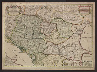
| Title |
Le Royaume de Hongrie et les estats qui en esté sujets et qui sont presentement la partie septentrionale de la Turquie en Europe. Tiré des memoires les plus nouveaux |
|||||||||||||||||||||||
| Description |
Deutsch: Ungarn, Südosteuropa |
|||||||||||||||||||||||
| Date | ||||||||||||||||||||||||
| Source | Leibniz-Institut für Ost- und Südosteuropaforschung (IOS) GeoPortOst | |||||||||||||||||||||||
| Creator |
Guillaume Sanson |
|||||||||||||||||||||||
| Permission (Reusing this file) |
|
|||||||||||||||||||||||
| Geotemporal data | ||||||||||||||||||||||||
| Date depicted | ||||||||||||||||||||||||
| Map location | Ungarn | |||||||||||||||||||||||
| Map type | Altkarte | |||||||||||||||||||||||
| Scale | Ca. 1:2 100 000 | |||||||||||||||||||||||
| Bounding box |
|
|||||||||||||||||||||||
| Georeferencing | ||||||||||||||||||||||||
| Bibliographic data | ||||||||||||||||||||||||
| Language | French | |||||||||||||||||||||||
| Archival data | ||||||||||||||||||||||||
| Collection |
|
|||||||||||||||||||||||
| Accession number |
BV044698782 |
|||||||||||||||||||||||

Licensing
edit
|
This work is in the public domain in its country of origin and other countries and areas where the copyright term is the author's life plus 70 years or fewer. | |
| This file has been identified as being free of known restrictions under copyright law, including all related and neighboring rights. | |
File history
Click on a date/time to view the file as it appeared at that time.
| Date/Time | Thumbnail | Dimensions | User | Comment | |
|---|---|---|---|---|---|
| current | 12:58, 19 February 2019 | | 11,082 × 8,222 (9.71 MB) | H.bauer26 (talk | contribs) | pattypan 18.02 |
You cannot overwrite this file.
File usage on Commons
There are no pages that use this file.