File:United States Administrative Divisions.png

Size of this preview: 800 × 520 pixels. Other resolutions: 320 × 208 pixels | 640 × 416 pixels | 1,024 × 665 pixels | 1,513 × 983 pixels.
Original file (1,513 × 983 pixels, file size: 124 KB, MIME type: image/png)
Captions
Captions
Add a one-line explanation of what this file represents
Summary
edit
| Description |
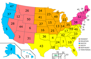
English: Map of the United States, with States and Territories marked in alphabetical order, states first. This map shows the official United States regions used by the US Census Bureau. It should not be changed to reflect casual indistinct divisions. |
| Date | 10 January 2007 (original upload date); 22 February 2007 (last version) |
| Source | Based on Image:Blank_map_of_the_United_States.PNG. |
| Author | Primalchaos at en.wikipedia / Later version(s) were uploaded by IAMTHEEGGMAN, Bootstoots at en.wikipedia. |
| Other versions |
|
Licensing
edit
| This work has been released into the public domain by its author, Primalchaos at English Wikipedia. This applies worldwide. In some countries this may not be legally possible; if so: Primalchaos grants anyone the right to use this work for any purpose, without any conditions, unless such conditions are required by law. |
Original upload log
edit
The original description page was here. All following user names refer to en.wikipedia.
- 2007-02-22 20:15 Primalchaos 1513×983×8 (127193 bytes) Reverted to earlier revision
- 2007-02-18 02:49 IAMTHEEGGMAN 1437×934×8 (321502 bytes) Reverted to earlier revision
- 2007-01-22 03:19 Bootstoots 1513×983×8 (127193 bytes) Reverted to earlier revision
- 2007-01-20 17:43 IAMTHEEGGMAN 1437×934×8 (321502 bytes) Added more regions (would you group Texas with Florida? think about it)
- 2007-01-10 01:46 Primalchaos 1513×983×8 (127193 bytes) Map of the United States, with States and Territories marked in alphabetical order, states first. Based on http://commons.wikimedia.org/wiki/Image:Blank_map_of_the_United_States.PNG
- 2007-01-10 01:12 Primalchaos 1513×983×8 (119190 bytes) Map of the United States, with States and Territories marked in alphabetical order, states first. Based on http://commons.wikimedia.org/wiki/Image:Blank_map_of_the_United_States.PNG
- transfered to Commons by User:Anrie using CommonsHelper.
File history
Click on a date/time to view the file as it appeared at that time.
| Date/Time | Thumbnail | Dimensions | User | Comment | |
|---|---|---|---|---|---|
| current | 14:45, 2 June 2008 | | 1,513 × 983 (124 KB) | File Upload Bot (Magnus Manske) (talk | contribs) | {{BotMoveToCommons|en.wikipedia}} {{Information |Description={{en|Map of the United States, with States and Territories marked in alphabetical order, states first. Based on http://commons.wikimedia.org/wiki/Image:Blank_map_of_the_United_States.PNG =Noti |
You cannot overwrite this file.
File usage on Commons
There are no pages that use this file.
File usage on other wikis
The following other wikis use this file:
- Usage on af.wikipedia.org
- Usage on ig.wikipedia.org
- Usage on tt.wikipedia.org