File:Universum (Wien) Lageplan 1856.jpg
Universum_(Wien)_Lageplan_1856.jpg (704 × 576 pixels, file size: 123 KB, MIME type: image/jpeg)
Captions
Captions
Summary
edit| DescriptionUniversum (Wien) Lageplan 1856.jpg |
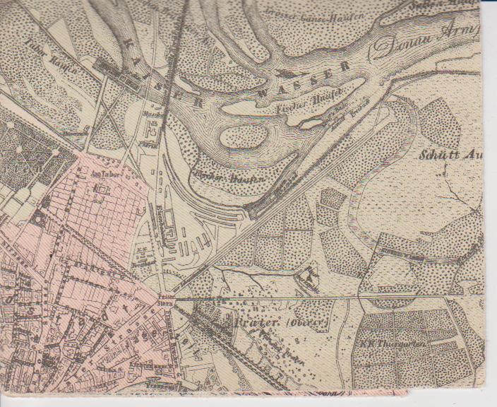
English: Part of a city map of Vienna in 1856, showing the location of the "Universum" entertainment establishment in an area close to the Danube, since 1850 being part of Vienna's 2nd district
Deutsch: Ausschnitt aus einem Stadtplan Wiens aus dem Jahr 1856, der den Standort des Vergnügungsetablissements "Universum" am Rand der Donauauen zeigt. Das Areal war seit 1850 Teil des 2. Wiener Gemeindebezirks. |
| Date | |
| Source | Wien und seine Vorstädte. 1856. Stadtplan |
| Author | Oertliche Entwicklung der Stadt Wien vom Mittelalter bis zur Gegenwart. Nach amtlichen Quellen bearbeitet vo n Conrad Grefe. Verlag des Wiener Magistrats |
Licensing
edit| Public domainPublic domainfalsefalse |
|
This work is in the public domain in its country of origin and other countries and areas where the copyright term is the author's life plus 70 years or fewer. Note that a few countries have copyright terms longer than 70 years: Mexico has 100 years, Jamaica has 95 years, Colombia has 80 years, and Guatemala and Samoa have 75 years. This image may not be in the public domain in these countries, which moreover do not implement the rule of the shorter term. Honduras has a general copyright term of 75 years, but it does implement the rule of the shorter term. Copyright may extend on works created by French who died for France in World War II (more information), Russians who served in the Eastern Front of World War II (known as the Great Patriotic War in Russia) and posthumously rehabilitated victims of Soviet repressions (more information).
| |
| This file has been identified as being free of known restrictions under copyright law, including all related and neighboring rights. | |
https://creativecommons.org/publicdomain/mark/1.0/PDMCreative Commons Public Domain Mark 1.0falsefalse
File history
Click on a date/time to view the file as it appeared at that time.
| Date/Time | Thumbnail | Dimensions | User | Comment | |
|---|---|---|---|---|---|
| current | 09:55, 22 April 2010 |  | 704 × 576 (123 KB) | Wolfgang J. Kraus~commonswiki (talk | contribs) | {{Information |Description={{en|1=Part of a city map of Vienna in 1856, showing the location of the "Universum" entertainment establishment in an area close to the Danube, since 1850 being part of Vienna's 2nd district}} {{de|1=Ausschnitt aus einem Stadtp |
You cannot overwrite this file.
File usage on Commons
The following page uses this file:
File usage on other wikis
The following other wikis use this file:
- Usage on de.wikipedia.org
- Usage on www.wikidata.org
Metadata
This file contains additional information such as Exif metadata which may have been added by the digital camera, scanner, or software program used to create or digitize it. If the file has been modified from its original state, some details such as the timestamp may not fully reflect those of the original file. The timestamp is only as accurate as the clock in the camera, and it may be completely wrong.
| _error | 0 |
|---|
