File:Urartu 610 585-en.svg

Size of this PNG preview of this SVG file: 800 × 513 pixels. Other resolutions: 320 × 205 pixels | 640 × 410 pixels | 1,024 × 657 pixels | 1,280 × 821 pixels | 2,560 × 1,641 pixels | 2,714 × 1,740 pixels.
Original file (SVG file, nominally 2,714 × 1,740 pixels, file size: 855 KB)
Captions
Captions
Add a one-line explanation of what this file represents
Summary edit
| Description |
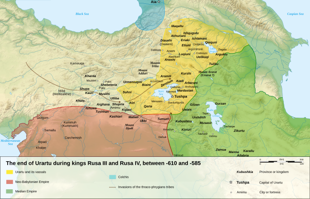
English: Map of the last years of the kingdom of Urartu, between -610 and -585.
Français : Carte en anglais des dernières années du royaume d'Urartu, entre -610 et -585. |
| Date | |
| Source |
Own work.
Sources :
Software used :
Other data :
|
| Author | Sémhur |
| Other versions |
See Urartu.
|
| SVG development | |
| Attribution (required by the license) | © Sémhur / Wikimedia Commons / |

| Camera location | | View this and other nearby images on: OpenStreetMap |
|---|
Licensing edit
I, the copyright holder of this work, hereby publish it under the following licenses:
| Copyleft: This work of art is free; you can redistribute it and/or modify it according to terms of the Free Art License. You will find a specimen of this license on the Copyleft Attitude site as well as on other sites. |
This file is licensed under the Creative Commons Attribution-Share Alike 4.0 International, 3.0 Unported, 2.5 Generic, 2.0 Generic and 1.0 Generic license.
- You are free:
- to share – to copy, distribute and transmit the work
- to remix – to adapt the work
- Under the following conditions:
- attribution – You must give appropriate credit, provide a link to the license, and indicate if changes were made. You may do so in any reasonable manner, but not in any way that suggests the licensor endorses you or your use.
- share alike – If you remix, transform, or build upon the material, you must distribute your contributions under the same or compatible license as the original.
You may select the license of your choice.
File history
Click on a date/time to view the file as it appeared at that time.
| Date/Time | Thumbnail | Dimensions | User | Comment | |
|---|---|---|---|---|---|
| current | 16:18, 10 January 2008 | | 2,714 × 1,740 (855 KB) | Sémhur (talk | contribs) | == Description == {{Information |Description= {{en| Map of the last years of the kingdom of Urartu, between -610 and -585.}} {{fr| Carte en anglais des dernières années du royaume d'Urartu, entre -610 et -585.}} |Source=Own work. {{clr}} Sources : * Top |
You cannot overwrite this file.
File usage on Commons
The following 4 pages use this file:
File usage on other wikis
The following other wikis use this file:
- Usage on af.wikipedia.org
- Usage on avk.wikipedia.org
- Usage on de.wikipedia.org
- Usage on en.wikipedia.org
- Usage on hr.wikipedia.org
- Usage on hy.wikipedia.org
- Usage on it.wikipedia.org
- Usage on ja.wikipedia.org
- Usage on ko.wikipedia.org
- Usage on nl.wikipedia.org
- Usage on sh.wikipedia.org
- Usage on simple.wikipedia.org