File:Urugami Island.jpg

Size of this preview: 554 × 600 pixels. Other resolutions: 222 × 240 pixels | 443 × 480 pixels | 709 × 768 pixels | 946 × 1,024 pixels | 1,891 × 2,048 pixels | 2,872 × 3,110 pixels.
Original file (2,872 × 3,110 pixels, file size: 1.76 MB, MIME type: image/jpeg)
Captions
Captions
Add a one-line explanation of what this file represents
Summary
edit
| Description |
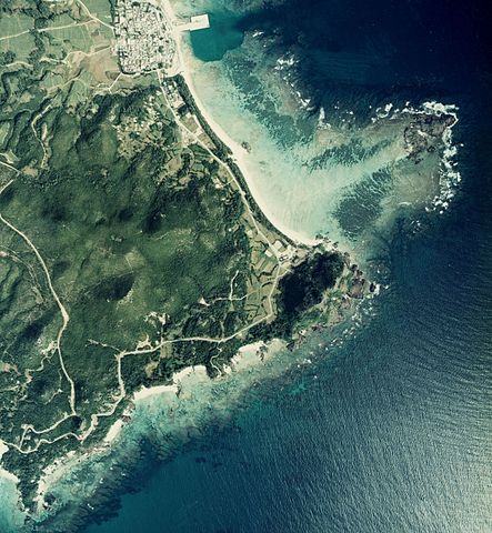
English: The right side of this image is Urugami Island, Izena, Okinawa prefecture, Japan.
日本語: 右側の岩礁が降神島(うるがみじま)、沖縄県島尻郡伊是名村。 |
| Date | |
| Source | Japanese Ministry of Land, Infrastructure, Transport and Tourism[1] |
| Author | Retouched by Kugel |
国土交通省の国土画像情報(カラー空中写真)を元に作成。
- 整理番号 COK-77-1
- 撮影年度 昭和52年度
- 地区名 沖縄本島
- 撮影コース C75
- 写真番号 5
Licensing
edit

|
The copyright holder of this file, the Ministry of Land, Infrastructure, Transport and Tourism of Japan, allows anyone to use it for any purpose, provided that the copyright holder is properly attributed. Redistribution, derivative work, commercial use, and all other use is permitted. |
Attribution:
Copyright © National Land Image Information (Color Aerial Photographs), Ministry of Land, Infrastructure, Transport and Tourism
|
 |
This image is copyrighted by the Ministry of Land, Infrastructure, Transport and Tourism of Japan. For terms of use, see the stipulation to use of National Land Information (in Japanese) and message from MLIT (in Japanese and English). When you display this image on an article, include the following phrase in the description: "Made based on National Land Image Information (Color Aerial Photographs), Ministry of Land, Infrastructure, Transport and Tourism".
|
File history
Click on a date/time to view the file as it appeared at that time.
| Date/Time | Thumbnail | Dimensions | User | Comment | |
|---|---|---|---|---|---|
| current | 05:48, 21 October 2012 | | 2,872 × 3,110 (1.76 MB) | Kugel~commonswiki (talk | contribs) | {{Information |Description ={{en|1=The right side of this image is Urugami Island, Izena, Okinawa prefecture, Japan.}} {{ja|1=右側の岩礁が降神島(うるがみじま)、沖縄県島尻郡伊是名村。}} |Source =Japanese Ministr... |
You cannot overwrite this file.
File usage on Commons
There are no pages that use this file.
File usage on other wikis
The following other wikis use this file:
- Usage on de.wikipedia.org
- Usage on ja.wikipedia.org
- Usage on www.wikidata.org
- Usage on zh-min-nan.wikipedia.org
- Usage on zh.wikipedia.org