File:VAMap-doton-Williamsburg.PNG
No higher resolution available.
VAMap-doton-Williamsburg.PNG (300 × 134 pixels, file size: 10 KB, MIME type: image/png)
Captions
Captions
Add a one-line explanation of what this file represents
Summary
edit
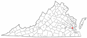
| Description | Adapted from Wikipedia's VA county maps by Seth Ilys. |
| Date | 21 May 2005 (original upload date) |
| Source | Transferred from en.wikipedia to Commons. |
| Author | The original uploader was Seth Ilys at English Wikipedia. |
Licensing
edit
| This file is licensed under the Creative Commons Attribution-Share Alike 3.0 Unported license. Subject to disclaimers. | ||
| ||
| This licensing tag was added to this file as part of the GFDL licensing update. |

|
Permission is granted to copy, distribute and/or modify this document under the terms of the GNU Free Documentation License, Version 1.2 or any later version published by the Free Software Foundation; with no Invariant Sections, no Front-Cover Texts, and no Back-Cover Texts. A copy of the license is included in the section entitled GNU Free Documentation License. Subject to disclaimers. |
Original upload log
edit
The original description page was here. All following user names refer to en.wikipedia.
- 2005-05-21 22:44 Seth Ilys 300×134×8 (8887 bytes) {{GFDL}}<br>Adapted from Wikipedia's VA county maps by [[User:Seth Ilys|Seth Ilys]].
File history
Click on a date/time to view the file as it appeared at that time.
| Date/Time | Thumbnail | Dimensions | User | Comment | |
|---|---|---|---|---|---|
| current | 16:24, 26 July 2012 | | 300 × 134 (10 KB) | Kmusser (talk | contribs) | Switch red to Williamsburg. |
| 17:37, 10 October 2006 |  | 300 × 134 (9 KB) | Haiaw~commonswiki (talk | contribs) | Adapted from Wikipedia's VA county maps by Seth Ilys. Copied from english wiki.. {{Information |Description= Williamsburg,VA on Virginia map |Source= en.wikipedia.org |Date= 10/10/2006 |Author= Seth Ilys |Permission= |other_versions= }} |
You cannot overwrite this file.
File usage on Commons
The following 2 pages use this file:
File usage on other wikis
The following other wikis use this file:
- Usage on ang.wikipedia.org
- Usage on ar.wikipedia.org
- Usage on ceb.wikipedia.org
- Usage on cy.wikipedia.org
- Usage on de.wikipedia.org
- Usage on en.wikipedia.org
- National Register of Historic Places listings in Williamsburg, Virginia
- User:LBourne/Scratch pad
- Wikipedia:Village pump (miscellaneous)/Archive 38
- Wikipedia:Graphics Lab/Map workshop/Archive/Aug 2012
- Wikipedia talk:WikiProject Virginia/Archive 6
- User talk:Sethant/Archive:2012-Winter
- User:Nyttend/Virginia NRHP/City of Williamsburg
- Usage on eo.wikipedia.org
- Usage on eu.wikipedia.org
- Usage on fa.wikipedia.org
- Usage on fr.wikipedia.org
- Usage on ht.wikipedia.org
- Usage on hu.wikipedia.org
- Usage on it.wikipedia.org
- Usage on ja.wikipedia.org
- Usage on nl.wikipedia.org
- Usage on ru.wikipedia.org
- Usage on sh.wikipedia.org
- Usage on sr.wikipedia.org
- Usage on sv.wikipedia.org
- Usage on tt.wikipedia.org
- Usage on ur.wikipedia.org
- Usage on vi.wikipedia.org
- Usage on vo.wikipedia.org
- Usage on www.wikidata.org
- Usage on zh.wikipedia.org