File:Vandalic War campaign map.png

Size of this preview: 800 × 540 pixels. Other resolutions: 320 × 216 pixels | 640 × 432 pixels | 1,024 × 691 pixels | 1,280 × 864 pixels | 1,700 × 1,147 pixels.
Original file (1,700 × 1,147 pixels, file size: 2.04 MB, MIME type: image/png)
Captions
Captions
Add a one-line explanation of what this file represents
Summary
edit| Description |
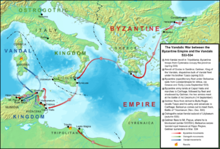
English: Map of the operations of the Vandalic War in 533-534, including the rebellions on Tripolitania and Sardinia. Topography taken from from DEMIS Mapserver, which are public domain, other wise self-made. Sources: The History of the Wars by Procopius of Caesarea; J.B. Bury, History of the Later Roman Empire; James Allan Stewart Evans, The Age of Justinian: The Circumstances of Imperial Power, ISBN 9780415022095; Ian Hughes, Belisarius: The Last Roman General, ISBN 9781594160851. |
| Date | |
| Source | Own work |
| Author | Cplakidas |
| Other versions |
[]
|


Licensing
edit
I, the copyright holder of this work, hereby publish it under the following license:
This file is licensed under the Creative Commons Attribution-Share Alike 3.0 Unported license.
- You are free:
- to share – to copy, distribute and transmit the work
- to remix – to adapt the work
- Under the following conditions:
- attribution – You must give appropriate credit, provide a link to the license, and indicate if changes were made. You may do so in any reasonable manner, but not in any way that suggests the licensor endorses you or your use.
- share alike – If you remix, transform, or build upon the material, you must distribute your contributions under the same or compatible license as the original.
File history
Click on a date/time to view the file as it appeared at that time.
| Date/Time | Thumbnail | Dimensions | User | Comment | |
|---|---|---|---|---|---|
| current | 08:49, 10 March 2013 | | 1,700 × 1,147 (2.04 MB) | Cplakidas (talk | contribs) | minor corrections |
| 10:35, 8 December 2011 |  | 1,700 × 1,147 (2.04 MB) | Cplakidas (talk | contribs) | minor corrections | |
| 20:39, 27 August 2011 |  | 1,697 × 1,150 (2.04 MB) | Cplakidas (talk | contribs) |
You cannot overwrite this file.
File usage on Commons
The following 10 pages use this file:
- User:Cplakidas
- File:Carte de la guerre de Vandales.png
- File:Mapa da Guerra Vândala.jpg
- File:Vandalic War campaign de.svg
- File:Vandalic War campaign map-ru.svg
- File:Vandalic War campaign map-zh.svg
- File:Vandalic War campaign map.png
- File:Vandalic War campaign map.svg
- Template:Other versions/Vandalic War campaign map
- Category:Vandalic War
File usage on other wikis
The following other wikis use this file:
- Usage on af.wikipedia.org
- Usage on ar.wikipedia.org
- Usage on azb.wikipedia.org
- Usage on bg.wikipedia.org
- Usage on ca.wikipedia.org
- Usage on cs.wikipedia.org
- Usage on de.wikipedia.org
- Usage on en.wikipedia.org
- Usage on es.wikipedia.org
- Usage on et.wikipedia.org
- Usage on fi.wikipedia.org
- Usage on fr.wikipedia.org
- Usage on he.wikipedia.org
- Usage on hu.wikipedia.org
- Usage on it.wikipedia.org
- Usage on ja.wikipedia.org
- Usage on la.wikipedia.org
- Usage on nl.wikipedia.org
- Usage on nn.wikipedia.org
- Usage on pl.wikipedia.org
- Usage on ro.wikipedia.org
- Usage on ru.wikipedia.org
View more global usage of this file.