File:Vanuatu map.png

Size of this preview: 275 × 598 pixels. Other resolutions: 110 × 240 pixels | 329 × 716 pixels.
Original file (329 × 716 pixels, file size: 72 KB, MIME type: image/png)
Captions
Captions
Add a one-line explanation of what this file represents
Summary
edit| Description |
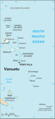
English: Map of Vanuatu based on Public Domain map downloaded from CIA website |
| Date | |
| Source | https://www.cia.gov/library/publications/the-world-factbook/geos/nh.html |
| Author | The World Factbook, United States Central Intelligence Agency |
| Other versions |
|

| Camera location | | View this and other nearby images on: OpenStreetMap |
|---|
Licensing
edit
This image is in the public domain because it contains materials that originally came from the United States Central Intelligence Agency's World Factbook.
|
 |
File history
Click on a date/time to view the file as it appeared at that time.
| Date/Time | Thumbnail | Dimensions | User | Comment | |
|---|---|---|---|---|---|
| current | 09:08, 20 June 2017 | | 329 × 716 (72 KB) | BlueMoses (talk | contribs) | User created page with UploadWizard |
You cannot overwrite this file.
File usage on Commons
There are no pages that use this file.
File usage on other wikis
The following other wikis use this file:
- Usage on bn.wikipedia.org
- Usage on en.wikipedia.org
- Usage on eo.wiktionary.org
- Usage on es.wikipedia.org
- Usage on id.wikipedia.org
- Usage on is.wikipedia.org
- Usage on nn.wikipedia.org
- Usage on uk.wikipedia.org
- Usage on vep.wikipedia.org