File:Ve-map 2010.png
No higher resolution available.
Ve-map_2010.png (330 × 353 pixels, file size: 33 KB, MIME type: image/png)
Captions
Captions
Add a one-line explanation of what this file represents
Summary
edit
| Description |
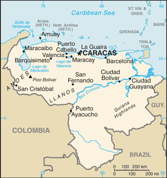
English: Map of Venezuela, showing major cities, rivers and bordering countries |
| Source | CIA World Factbook |
| Author | CIA |
Updated version of File:Ve-map.png
Licensing
edit
This image is in the public domain because it contains materials that originally came from the United States Central Intelligence Agency's World Factbook.
|
 |
File history
Click on a date/time to view the file as it appeared at that time.
| Date/Time | Thumbnail | Dimensions | User | Comment | |
|---|---|---|---|---|---|
| current | 20:59, 30 March 2010 | | 330 × 353 (33 KB) | Wikisteve (talk | contribs) | {{Information |Description={{en|1=Map of Venezuela, showing major cities, rivers and bordering countries}} |Source=[https://www.cia.gov/library/publications/the-world-factbook/graphics/maps/large/ve-map.gif CIA World Factbook] |Author=CIA |Date= |Permissi |
You cannot overwrite this file.
File usage on Commons
There are no pages that use this file.