File:Veghel-Amert-OpenTopo.jpg

Size of this preview: 600 × 600 pixels. Other resolutions: 240 × 240 pixels | 480 × 480 pixels | 749 × 749 pixels.
Original file (749 × 749 pixels, file size: 674 KB, MIME type: image/jpeg)
Captions
Captions
Add a one-line explanation of what this file represents
Summary edit
| Description |
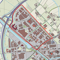
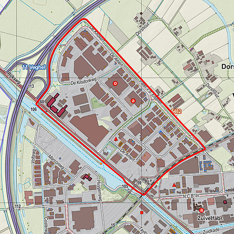
Nederlands: Topografische kaart van bedrijventerrein de Amert in Veghel. Resolutie: 400 pixels/km.
Kaartbeeld samengesteld uit de open geodata van de Top10NL en Top25namen (Kadaster), Creative Commons-BY licentie. Gebouwvlakken uit open geodata BAG extract. Wegen uit de OpenStreetMap, OpenStreetMap community. Reliëfschaduw uit de Actuele Hoogtekaart AHN2. Samenstelling en kleurenschema: Jan-Willem van Aalst, met QGIS. Zie ook de Legenda. |
| Date | |
| Source | |
| Author | Janwillemvanaalst, edited by J187B |

Licensing edit
I, the copyright holder of this work, hereby publish it under the following license:
This file is licensed under the Creative Commons Attribution-Share Alike 3.0 Unported license.
- You are free:
- to share – to copy, distribute and transmit the work
- to remix – to adapt the work
- Under the following conditions:
- attribution – You must give appropriate credit, provide a link to the license, and indicate if changes were made. You may do so in any reasonable manner, but not in any way that suggests the licensor endorses you or your use.
- share alike – If you remix, transform, or build upon the material, you must distribute your contributions under the same or compatible license as the original.
File history
Click on a date/time to view the file as it appeared at that time.
| Date/Time | Thumbnail | Dimensions | User | Comment | |
|---|---|---|---|---|---|
| current | 21:09, 17 April 2015 | | 749 × 749 (674 KB) | J187B (talk | contribs) | User created page with UploadWizard |
You cannot overwrite this file.
File usage on Commons
There are no pages that use this file.
File usage on other wikis
The following other wikis use this file:
- Usage on nl.wikipedia.org