File:Verlaufskarte Inn DE.png
Size of this preview: 674 × 599 pixels. Other resolutions: 270 × 240 pixels | 540 × 480 pixels | 864 × 768 pixels | 1,152 × 1,024 pixels | 2,117 × 1,882 pixels.
Original file (2,117 × 1,882 pixels, file size: 5.54 MB, MIME type: image/png)
Captions
Captions
Add a one-line explanation of what this file represents
Summary edit
| Description |
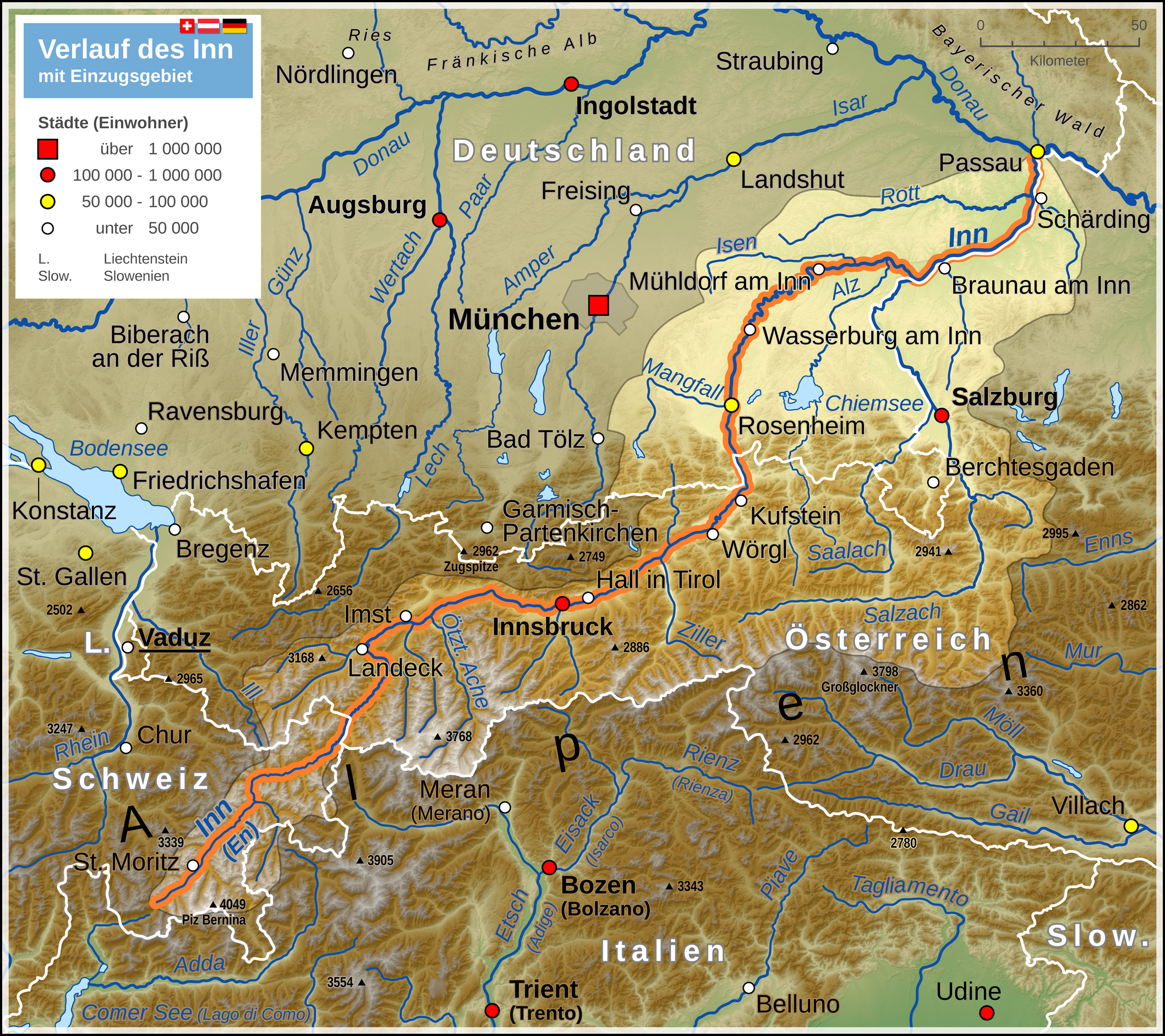
Deutsch: Verlaufskarte des Inn mit Darstellung des Einzugsgebietes
English: Map of Inn river (including drainage basin) |
| Date | |
| Source |
Own work Map created using: |
| Author | Thoroe |
| Permission (Reusing this file) |
Map data (c) OpenStreetMap (and) contributors, CC-BY-SA |

|
This map has been made or improved in the German Kartenwerkstatt (Map Lab). You can propose maps to improve as well.
|
Licensing edit
This file is licensed under the Creative Commons Attribution-Share Alike 2.0 Generic license.
Attribution: Thomas Römer/OpenStreetMap data
- You are free:
- to share – to copy, distribute and transmit the work
- to remix – to adapt the work
- Under the following conditions:
- attribution – You must give appropriate credit, provide a link to the license, and indicate if changes were made. You may do so in any reasonable manner, but not in any way that suggests the licensor endorses you or your use.
- share alike – If you remix, transform, or build upon the material, you must distribute your contributions under the same or compatible license as the original.
File history
Click on a date/time to view the file as it appeared at that time.
| Date/Time | Thumbnail | Dimensions | User | Comment | |
|---|---|---|---|---|---|
| current | 14:41, 6 July 2014 | | 2,117 × 1,882 (5.54 MB) | Thoroe (talk | contribs) | ein paar mehr Flüsse |
| 15:06, 3 May 2013 |  | 2,117 × 1,882 (5.52 MB) | Thoroe (talk | contribs) | Einzugsgebiet korrigiert +einige Gewässer | |
| 21:24, 3 August 2012 |  | 1,059 × 941 (2 MB) | Kontrollstellekundl (talk | contribs) | Das Standesamt Udine bestätigte für den 31. Januar 2012 erstmals seit 25 Jahren wieder mehr als 100.000 Einwohner - von Gelb auf Rot.<ref>http://messaggeroveneto.gelocal.it/cronaca/2012/02/03/news/udine-torna-sopra-i-100-mila-abitanti-1.3140196</... | |
| 14:48, 18 October 2011 |  | 1,059 × 941 (1.88 MB) | Thoroe (talk | contribs) | farbliche Überarbeitung, Details am Einzugsgebiet | |
| 18:31, 9 October 2011 |  | 1,059 × 941 (1.84 MB) | Thoroe (talk | contribs) | Einzugsgebiet, Legende reduziert, Geländehöhen, noch ein paar Nebenflüsse etc. | |
| 10:44, 6 October 2011 |  | 1,059 × 941 (1.8 MB) | Thoroe (talk | contribs) | mehr Orte und diverse Änderungen | |
| 14:19, 1 October 2011 |  | 1,059 × 941 (1.78 MB) | Thoroe (talk | contribs) | {{Information |Description ={{de|1=Verlauf des Inn}} |Source ={{own}} Map created using: *[http://gmt.soest.hawaii.edu Generic Mapping Tools (GMT)] with SRTM3 V2 data *[http://www.openstreetmap.org OpenStreetMap] data *[[:File:Flag |
You cannot overwrite this file.
File usage on Commons
The following 3 pages use this file:
File usage on other wikis
The following other wikis use this file:
- Usage on af.wikipedia.org
- Usage on als.wikipedia.org
- Usage on an.wikipedia.org
- Usage on bg.wikipedia.org
- Usage on bs.wikipedia.org
- Usage on cs.wikipedia.org
- Usage on da.wikipedia.org
- Usage on de.wikipedia.org
- Usage on el.wikipedia.org
- Usage on en.wikipedia.org
- Usage on eo.wikipedia.org
- Usage on es.wikipedia.org
- Usage on frr.wikipedia.org
- Usage on fr.wikipedia.org
- Usage on he.wikipedia.org
- Usage on hr.wikipedia.org
- Usage on hu.wikipedia.org
- Usage on hy.wikipedia.org
- Usage on incubator.wikimedia.org
- Usage on it.wikipedia.org
- Usage on ja.wikipedia.org
- Usage on ka.wikipedia.org
- Usage on ko.wikipedia.org
- Usage on lld.wikipedia.org
- Usage on mk.wikipedia.org
- Usage on ml.wikipedia.org
- Usage on nl.wikipedia.org
- Usage on nn.wikipedia.org
- Usage on no.wikipedia.org
- Usage on pl.wikipedia.org
- Usage on pl.wiktionary.org
- Usage on pnb.wikipedia.org
- Usage on rm.wikipedia.org
- Usage on ru.wikipedia.org
- Usage on sco.wikipedia.org
- Usage on sh.wikipedia.org
- Usage on sl.wikipedia.org
- Usage on sr.wikipedia.org
View more global usage of this file.