File:Verteilerkreis Köln – Kugelpanorama aus der Luft 2020.jpg

Original file (8,192 × 4,096 pixels, file size: 4.92 MB, MIME type: image/jpeg)
Captions
Captions
Summary
edit
| 360° | View in 360° panoramic viewer
|
|---|
| Description |
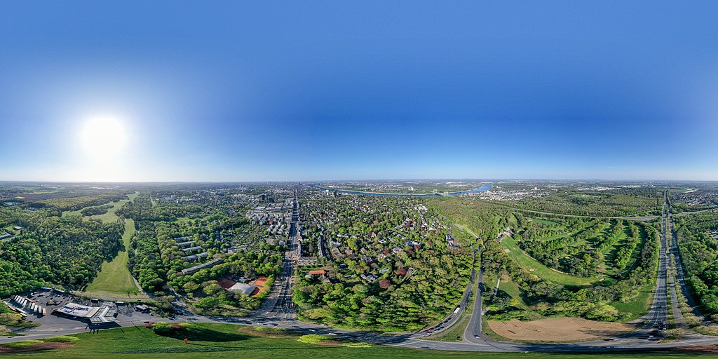
Deutsch: Verteilerkreis Köln (auch Bonner Verteiler genannt). Kugelpanorama aus der Luft im April 2020. Das Foto setzt sich aus 24 Einzelbildern zusammen; der obere Teil des Himmels ist künstlich mit Blau aufgefüllt. Die Drohne befand sich exakt über dem Zentrum des großen Kreisverkehrs, und zwar in etwas über 200 m über Grund. Die hier erlaubte Höhe von 50 m (wegen der erweiterten Kontrollzone des Flughafens Köln/Bonn) konnte ich durch eine Ausnahmegenehmigung der Landesregierung und einer expliziten Höhenfreigabe für diesen Timeslot durch die Deutsche Flugsicherung erweitern. Wegen der Covid-19-Pandemie herrschte an diesem Ostermontag ein sehr geringer Verkehr.
Vom Kreisverkehr gehen im Prinzip vier große Straßen ab: nach Norden die Bonnerstraße, Richtung Innenstadt. In der Ferne ist der Kölner Dom zu sehen. Von West nach Ost verläuft die Militärringstraße, welche im Grunde der dritte Ring um Köln ist. Man sieht sein Ende im Osten am Rhein. In südlicher Richtung beginnt die A555 am Verteilerkreis, woran sich unmittelbar das Autobahnkreuz Köln-Süd anschließt, wo die A4 die A555 kreuzt. Betrachten wir die Quadranten um den Verteilerkreis: Im Südosten befindet sich der Forstbotanische Garten mit dem Hahnwald, woran sich Rodenkirchen anschließt, im Nordosten der Stadtteil Marienburg, im Westen Raderthal, im Südwesten Giesdorf. Die dem Foto näheste Rheinbrücke ist die Rodenkirchener Brücke, über die die A4 führt. Die Stadtteile auf der östlichen Rheinseite sind Westhoven und Poll. Auch Deutz mit seinem TÜV-Hochhaus ist zu erkennen. Weil die Sicht auf dem Bild gut ist, kann man im Westen, hinter den Kohlekraftwerken, in der Ferne die Eifel und im Südosten das Siebengebirge erkennen. Bei Wiederverwendung dieses Fotos bitte unbedingt den Namen (Maximilian Schönherr) und den Link zu dieser Wikimedia-Webseite angeben! |
| Date | |
| Source | Own work |
| Author | Maximilian Schönherr |
Licensing
edit
- You are free:
- to share – to copy, distribute and transmit the work
- to remix – to adapt the work
- Under the following conditions:
- attribution – You must give appropriate credit, provide a link to the license, and indicate if changes were made. You may do so in any reasonable manner, but not in any way that suggests the licensor endorses you or your use.
- share alike – If you remix, transform, or build upon the material, you must distribute your contributions under the same or compatible license as the original.
File history
Click on a date/time to view the file as it appeared at that time.
| Date/Time | Thumbnail | Dimensions | User | Comment | |
|---|---|---|---|---|---|
| current | 16:31, 13 April 2020 | | 8,192 × 4,096 (4.92 MB) | Maximilian Schönherr (talk | contribs) | Uploaded own work with UploadWizard |
You cannot overwrite this file.
File usage on Commons
The following page uses this file:
File usage on other wikis
The following other wikis use this file:
- Usage on de.wikipedia.org
- Usage on www.wikidata.org