File:View from Kibbutz Kfar Giladi into Hula Valley 2.JPG

Size of this preview: 800 × 533 pixels. Other resolutions: 320 × 213 pixels | 640 × 427 pixels | 1,024 × 683 pixels | 1,280 × 853 pixels | 2,560 × 1,707 pixels | 4,608 × 3,072 pixels.
Original file (4,608 × 3,072 pixels, file size: 8.78 MB, MIME type: image/jpeg)
Captions
Captions
Add a one-line explanation of what this file represents
Summary
edit| Description |
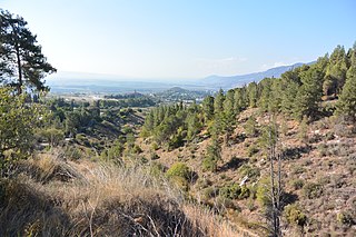
Deutsch: Von südlichem Ende des Kibbuz Kfar Giladi sieht man links die Golanhöhen auf der anderen Seite der Hula-Ebene. Unten rechts sieht man Teile von Kiryat Shmona. In der kleinen Senke sind Kunstgegenstände ausgestellt.
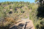
Links verläuft der Pfad der Verwundeten.
English: From southern end of Kibbutz Kfar Giladi you can see the Golan Heights on the left other side of Hula Valley. Down right are parts of Kiryat Shmona. In the small valley in front are some art is exhibet.
You can see the Path of the Wounded on the left. |
| Date | |
| Source | Own work |
| Author | Jotpe |
| Other versions |
|
| Place[1] | Deutsch: מסעף כפר גלעדי, 9977, Galil Elyon Regional Council, Nordbezirk, Israel English: מסעף כפר גלעדי, 9977, Galil Elyon Regional Council, North District, Israel עברית: מסעף כפר גלעדי, 9977, מועצה אזורית גליל עליון, מחוז הצפון, ישראל |
| Image Number | 60 |

| Camera location | | View this and other nearby images on: OpenStreetMap |
|---|
Navigation for Fotoproject Israel National Trail 2014
editnext
-
 View from Kibbutz Kfar Giladi into Hula Valley.JPG
 -
 View from Kibbutz Kfar Giladi into Hula Valley 2.JPG
 -
 Moses statue at Path of the Wounded.JPG
 -
 Moses statue at Path of the Wounded 2.jpg
 -
 Path of the Wounded.JPG
 -
 Soldier memorial in Kfar Giladi.JPG


The production, editing or release of this file was supported by the Community-Budget of Wikimedia Deutschland. To see other files made with the support of Wikimedia Deutschland, please see the category Supported by Wikimedia Deutschland. |
Licensing
edit
I, the copyright holder of this work, hereby publish it under the following license:
This file is licensed under the Creative Commons Attribution-Share Alike 4.0 International license.
- You are free:
- to share – to copy, distribute and transmit the work
- to remix – to adapt the work
- Under the following conditions:
- attribution – You must give appropriate credit, provide a link to the license, and indicate if changes were made. You may do so in any reasonable manner, but not in any way that suggests the licensor endorses you or your use.
- share alike – If you remix, transform, or build upon the material, you must distribute your contributions under the same or compatible license as the original.
Notes for Share Alike in Openstreetmap
editDeutsch: Informationen aus diesem Dokument/Foto können expliziet für Openstreetmap verwendet werden. Als Share-Alike reicht mir User jotpe @ Wikimedia Commons: View from Kibbutz Kfar Giladi into Hula Valley 2.JPG in der Source-Angabe beim Upload der OSM-Daten.
English: Information in this document / photo can be expliziet used for OpenStreetMap. Share-Alike is fullfilled by User jotpe @ Wikimedia Commons: View from Kibbutz Kfar Giladi into Hula Valley 2.JPG in the source field specified on upload of OSM data.
Sources
edit
| Annotations | This image is annotated: View the annotations at Commons |
File history
Click on a date/time to view the file as it appeared at that time.
| Date/Time | Thumbnail | Dimensions | User | Comment | |
|---|---|---|---|---|---|
| current | 07:14, 4 January 2015 | | 4,608 × 3,072 (8.78 MB) | Jotpe (talk | contribs) |
You cannot overwrite this file.
File usage on Commons
The following 7 pages use this file:
- User:Nicolas Rück (WMDE)/Supported by Wikimedia Deutschland 2015/3
- File:Hilly path near Kibbutz Maayan Barukh.JPG
- File:Moses statue at Path of the Wounded.JPG
- File:Moses statue at Path of the Wounded 2.jpg
- File:Soldier memorial in Kfar Giladi.JPG
- File:View from Kibbutz Kfar Giladi into Hula Valley.JPG
- File:View from Kibbutz Kfar Giladi into Hula Valley 2.JPG
File usage on other wikis
The following other wikis use this file:
- Usage on de.wikipedia.org