File:View from Shafer Trail Road in Canyonlands.jpeg
Size of this preview: 800 × 477 pixels. Other resolutions: 320 × 191 pixels | 640 × 382 pixels | 1,024 × 611 pixels | 1,600 × 954 pixels.
Original file (1,600 × 954 pixels, file size: 391 KB, MIME type: image/jpeg)
Captions
Captions
Add a one-line explanation of what this file represents
Summary
edit
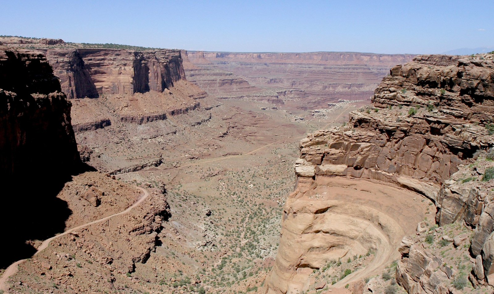
English: Photo taken by Daniel Mayer in late June 2005.
(Note, the photo is High Resolution, expandible). The view is east-northeastwards, toward (unseen) Colorado River region, south side of en:Dead Horse Point State Park, Shafer Trail (road), in Shafer Canyon region-(northeast Canyonlands National Park). The photo is taken from upper cliff, "bedded-cliff" of en:Kayenta Formation, above and in contact with the vertical-cliff of en:Wingate Sandstone.
The upper canyon is in close-up, with Shafer Trail descending to right, and skirting 3-Points, on the white en:White Rim Sandstone shelf-(overlooking the Lower Canyon, in the photo distance). There are many geologic units (in view) below the white shelf, in the distant canyon view. (see sequence, Canyonlands strat: File:Canyonlands strat.jpg). Some of the sequence visible below the White Rim Sandstone:
- Organ Rock Formation (bedded)
- Cedar Mesa Sandstone
- Elephant Canyon Formation & Halgaito Formation (slopes)
- Honaker Trail, Paradox, & Pinkerton Trail Formations
Above the White Rim Sandstone platform (shelf), and below the vertical-cliffs of the en:Wingate Sandstone-(this is in close view-(also distant view), Shafer Trail descending through it), are 8-units: from Wingate: 3-subunits (en:Chinle Formation-(only 3 units in Canyonlands)-(many states, AZ, NM, UT, CO, etc?), 4-subunits of en:Moenkopi Formation-many states-(north border AZ), and Black Box Dolomite (visible?).
The 8-subunits are:
- 3-(Chinle)-Church Rock Member
- 2-(Chinle)-Moss Back Conglomerate
- 1-(Chinle)-Temple Mountain Member
- 4 & 3-(Moenkopi)-Moody Canyon Member and Torrey Member
- 2-(Moenkopi)-Sinbad Limestone
- 1-(Moenkopi)-Black Dragon Member
- Black Box Dolomite
Licensing
edit
I, the copyright holder of this work, hereby publish it under the following license:
This file is licensed under the Creative Commons Attribution-Share Alike 2.5 Generic license.
- You are free:
- to share – to copy, distribute and transmit the work
- to remix – to adapt the work
- Under the following conditions:
- attribution – You must give appropriate credit, provide a link to the license, and indicate if changes were made. You may do so in any reasonable manner, but not in any way that suggests the licensor endorses you or your use.
- share alike – If you remix, transform, or build upon the material, you must distribute your contributions under the same or compatible license as the original.
File history
Click on a date/time to view the file as it appeared at that time.
| Date/Time | Thumbnail | Dimensions | User | Comment | |
|---|---|---|---|---|---|
| current | 00:04, 15 March 2006 | | 1,600 × 954 (391 KB) | Mav (talk | contribs) | == Summary == Photo taken by Daniel Mayer in late June 2005. == Licensing == {{self|cc-by-sa-2.5}} category:Canyonlands National Park |
You cannot overwrite this file.
File usage on Commons
The following page uses this file:
File usage on other wikis
The following other wikis use this file:
- Usage on ca.wikipedia.org
- Usage on fr.wikipedia.org