File:View of Latona Bridge and Lake Union, Seattle, circa 1915 (MOHAI 11084).jpg
View_of_Latona_Bridge_and_Lake_Union,_Seattle,_circa_1915_(MOHAI_11084).jpg (700 × 553 pixels, file size: 49 KB, MIME type: image/jpeg)
Captions
Captions
Summary
edit.jpg&action=edit§ion=1)
| English: View of Latona Bridge and Lake Union, Seattle, circa 1915
( |
||||||||||||||||||||||||
|---|---|---|---|---|---|---|---|---|---|---|---|---|---|---|---|---|---|---|---|---|---|---|---|---|
| Photographer |
Webster & Stevens |
|||||||||||||||||||||||
| Title |
English: View of Latona Bridge and Lake Union, Seattle, circa 1915 |
|||||||||||||||||||||||
| Description |
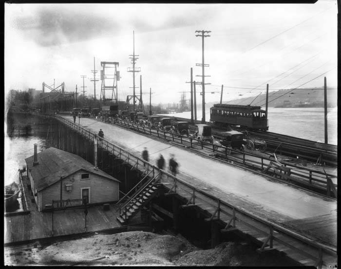
English: Seattle's first substantial bridge to cross Lake Union was the Latona Bridge, a pile-driven, fixed-span bridge linking the Eastlake neighborhood to the University District at Portage Bay. Constructed in 1891 for Seattle pioneer and investor David T. Denny (1832-1903) as an extension of his Rainier Power & Railway Co., the bridge was rebuilt in 1902 to allow pedestrian and vehicular traffic. When the Lake Washington Ship Canal opened in 1917, linking Lake Washington, Lake Union, and the Puget Sound, the Latona Bridge had to be remodeled again. In 1919 the University Bridge, a bascule bridge, replaced the Latona Bridge. This image of the Latona Bridge was taken facing south west and looking towards Lake Union, with Queen Anne Hill visible in the distance at the far right of the frame. Notable in this image are the many ways people traveled at the time: by boats, on foot, and in horse-drawn wagons, automobiles, trucks, and electric trolleys. Caption information source: "Latona Bridge and University Bridge (Seattle)" by John Caldbick, HistoryLink.org Essay 20389 Caption information source: https://pauldorpat.com/2013/06/29/seattle-now-then-the-latona-bridge
|
|||||||||||||||||||||||
| Depicted place |
English: Union, Lake (Wash.)
United States--Washington (State)--Seattle |
|||||||||||||||||||||||
| Date | circa 1915 | |||||||||||||||||||||||
| Medium |
English: 1 nitrate negative: b&w; sulfiding |
|||||||||||||||||||||||
| Dimensions | height: 8 in (20.3 cm); width: 10 in (25.4 cm) | |||||||||||||||||||||||
| Collection |
|
|||||||||||||||||||||||
| Current location | ||||||||||||||||||||||||
| Accession number | ||||||||||||||||||||||||
| Source |
English: Museum of History and Industry |
|||||||||||||||||||||||
| Permission (Reusing this file) |
|
|||||||||||||||||||||||
| Credit Line | MOHAI, PEMCO Webster & Stevens Collection, 1983.10.1383.2 | |||||||||||||||||||||||
File history
Click on a date/time to view the file as it appeared at that time.
| Date/Time | Thumbnail | Dimensions | User | Comment | |
|---|---|---|---|---|---|
| current | 17:45, 19 November 2020 | | 700 × 553 (49 KB) | BMacZeroBot (talk | contribs) | Batch upload (Commons:Batch uploading/University of Washington Digital Collections) |
You cannot overwrite this file.
File usage on Commons
The following page uses this file:
.jpg)
.jpg&oldid=708290282)