File:View of rear (south) wall, looking slightly northeast. - Ed Robinson House, 214 Oregon Street, Georgetown, Scott County, KY HABS KY-216-2.tif

Size of this JPG preview of this TIF file: 746 × 600 pixels. Other resolutions: 299 × 240 pixels | 597 × 480 pixels | 955 × 768 pixels | 1,274 × 1,024 pixels | 2,547 × 2,048 pixels | 5,388 × 4,332 pixels.
Original file (5,388 × 4,332 pixels, file size: 22.26 MB, MIME type: image/tiff)
Captions
Captions
Add a one-line explanation of what this file represents
Summary edit
| View of rear (south) wall, looking slightly northeast. - Ed Robinson House, 214 Oregon Street, Georgetown, Scott County, KY | ||||
|---|---|---|---|---|
| Title |
View of rear (south) wall, looking slightly northeast. - Ed Robinson House, 214 Oregon Street, Georgetown, Scott County, KY |
|||
| Description |
Barlow, Sally; Georgetown Urban Renewal and Community Development Agency; Calloway, Deborah, transmitter; O'Malley, Nancy, historian; Perkins, Charlie, photographer |
|||
| Depicted place | Kentucky; Scott County; Georgetown | |||
| Date | Documentation compiled after 1933 | |||
| Dimensions | 4 x 5 in. | |||
| Current location |
Library of Congress Prints and Photographs Division Washington, D.C. 20540 USA http://hdl.loc.gov/loc.pnp/pp.print |
|||
| Accession number |
HABS KY-216-2 |
|||
| Credit line |
|
|||
| Notes |
|
|||
| Source | https://www.loc.gov/pictures/item/ky0303.photos.210062p | |||
| Permission (Reusing this file) |
|
|||

File history
Click on a date/time to view the file as it appeared at that time.
| Date/Time | Thumbnail | Dimensions | User | Comment | |
|---|---|---|---|---|---|
| current | 04:38, 20 July 2014 | 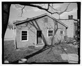 | 5,388 × 4,332 (22.26 MB) | Fæ (talk | contribs) | GWToolset: Creating mediafile for Fæ. HABS 16 July 2014 (1201:1400) |
You cannot overwrite this file.
File usage on Commons
The following page uses this file: