File:Vikingen tijd.png
No higher resolution available.
Vikingen_tijd.png (697 × 438 pixels, file size: 116 KB, MIME type: image/png)
Captions
Captions
Add a one-line explanation of what this file represents
Summary edit
| Description |
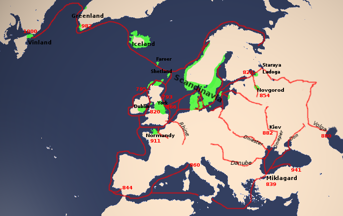
Nederlands: Map of medieval North Germanic territories and expeditions (Orthographic projection (cartography)), based on http://home.online.no/~anlun/tipi/vrout.jpg
en wiki |
| Date | 2 October 2005 (original upload date) |
| Source | Transferred from nl.wikipedia to Commons by Koektrommel using CommonsHelper. |
| Author | The original uploader was Hardscarf at Dutch Wikipedia. |
Licensing edit

|
Permission is granted to copy, distribute and/or modify this document under the terms of the GNU Free Documentation License, Version 1.2 or any later version published by the Free Software Foundation; with no Invariant Sections, no Front-Cover Texts, and no Back-Cover Texts. A copy of the license is included in the section entitled GNU Free Documentation License. |
| This file is licensed under the Creative Commons Attribution-Share Alike 3.0 Unported license. | ||
| ||
| This licensing tag was added to this file as part of the GFDL licensing update. |
Original upload log edit
The original description page was here. All following user names refer to nl.wikipedia.
- 2005-10-02 09:47 Hardscarf 697×438× (118452 bytes) [http://en.wikipedia.org/wiki/Image:Viking_Age.png en wiki] Oorspronkelijk gebaseerd op [http://home.online.no/~anlun/tipi/vrout.jpg]
See also edit
File history
Click on a date/time to view the file as it appeared at that time.
| Date/Time | Thumbnail | Dimensions | User | Comment | |
|---|---|---|---|---|---|
| current | 14:44, 18 December 2009 | | 697 × 438 (116 KB) | File Upload Bot (Magnus Manske) (talk | contribs) | {{BotMoveToCommons|nl.wikipedia|year={{subst:CURRENTYEAR}}|month={{subst:CURRENTMONTHNAME}}|day={{subst:CURRENTDAY}}}} {{Information |Description={{nl|Map of medieval North Germanic territories and expeditions (Orthographic projection (cartography)), bas |
You cannot overwrite this file.
File usage on Commons
The following page uses this file:
File usage on other wikis
The following other wikis use this file:
- Usage on lv.wikipedia.org
- Usage on nl.wikipedia.org
- Usage on ro.wikipedia.org