File:Vilayet of Istanbul, Mutasarrifate of Çatalca (1881) Boundaries and Ethnic Makeup.png

Original file (7,262 × 3,320 pixels, file size: 2 MB, MIME type: image/png)
Captions
Captions
Summary
edit_Boundaries_and_Ethnic_Makeup.png&action=edit§ion=1)
| Description |
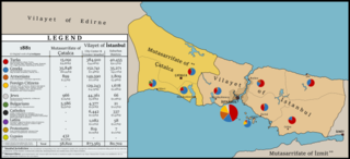
English: Map showing administrative boundaries and districtwise ethnic makeup based on 1881 Census of the Turkish Empire for Vilayet of Istanbul and Mutasarrifate of Çatalca.
Sources: Kemal H. Karpat, Ottoman Population 1830-1914: Demographic and Social Characteristics, 1985, University of Wisconsin "Memalik-i Mahruse-yi Şahane'ye Mahsus Mükemmel ve Mufassal Atlas", Ottoman Archives Vital CUINET, La Turquie d'Asie. Geographie administrative, statistique, descriptive et raisonné e de chaque province de l'Asie-Mineure, 1894, British Library Huber, R. (1899). “Empire Ottoman: Division administrative” US Library of Congress Archives, Geography and Map Division Türkçe: Türk İmparatorluğu 1881 Nüfus Sayımı sonuçlarına göre İstanbul Vilayeti ve Çatalca Mutasarrıflığı idari sınırları ve kaza bazında etnik dağılımları gösteren harita.
Kaynaklar: Kemal H. Karpat, Ottoman Population 1830-1914: Demographic and Social Characteristics, 1985, University of Wisconsin "Memalik-i Mahruse-yi Şahane'ye Mahsus Mükemmel ve Mufassal Atlas", Osmanlı Arşivleri Vital CUINET, La Turquie d'Asie. Geographie administrative, statistique, descriptive et raisonné e de chaque province de l'Asie-Mineure, 1894, British Library Huber, R. (1899). “Empire Ottoman: Division administrative” US Library of Congress Archives, Geography and Map DivisionDeutsch: Die Karte zeigt die Verwaltungsgrenzen und bezirksweise ethnische Verteilung des Istanbul Vilayets und Çatalca Mutasarrifliks nach dem Zensus des Türkisches Reiches von 1881
Quellen: Kemal H. Karpat, Ottoman Population 1830-1914: Demographic and Social Characteristics, 1985, University of Wisconsin "Memalik-i Mahruse-yi Şahane'ye Mahsus Mükemmel ve Mufassal Atlas", Ottoman Archives Vital CUINET, La Turquie d'Asie. Geographie administrative, statistique, descriptive et raisonné e de chaque province de l'Asie-Mineure, 1894, British Library Huber, R. (1899). “Empire Ottoman: Division administrative” US Library of Congress Archives, Geography and Map DivisionMagyar: 1881. évi Török Birodalomi népszámlálásabol Istanbul Vilayetje és Çatalca Mutasarriflikje hivatalos határok és megyéki etnikai megoszlás térképe
Forrás: Kemal H. Karpat, Ottoman Population 1830-1914: Demographic and Social Characteristics, 1985, University of Wisconsin "Memalik-i Mahruse-yi Şahane'ye Mahsus Mükemmel ve Mufassal Atlas", Ottoman Archives Vital CUINET, La Turquie d'Asie. Geographie administrative, statistique, descriptive et raisonné e de chaque province de l'Asie-Mineure, 1894, British Library Huber, R. (1899). “Empire Ottoman: Division administrative” US Library of Congress Archives, Geography and Map Division |
| Date | |
| Source | Own work |
| Author | Berkaysnklf |
Licensing
edit_Boundaries_and_Ethnic_Makeup.png&action=edit§ion=2)
- You are free:
- to share – to copy, distribute and transmit the work
- to remix – to adapt the work
- Under the following conditions:
- attribution – You must give appropriate credit, provide a link to the license, and indicate if changes were made. You may do so in any reasonable manner, but not in any way that suggests the licensor endorses you or your use.
- share alike – If you remix, transform, or build upon the material, you must distribute your contributions under the same or compatible license as the original.
File history
Click on a date/time to view the file as it appeared at that time.
| Date/Time | Thumbnail | Dimensions | User | Comment | |
|---|---|---|---|---|---|
| current | 13:15, 12 May 2021 | | 7,262 × 3,320 (2 MB) | BRKY24 (talk | contribs) | Uploaded own work with UploadWizard |
You cannot overwrite this file.
File usage on Commons
There are no pages that use this file.
File usage on other wikis
The following other wikis use this file:
- Usage on de.wikipedia.org
_Boundaries_and_Ethnic_Makeup.png&oldid=649285745)