File:Vindobona 250-300 no.svg

Size of this PNG preview of this SVG file: 626 × 599 pixels. Other resolutions: 251 × 240 pixels | 502 × 480 pixels | 803 × 768 pixels | 1,070 × 1,024 pixels | 2,140 × 2,048 pixels | 1,116 × 1,068 pixels.
Original file (SVG file, nominally 1,116 × 1,068 pixels, file size: 268 KB)
Captions
Captions
Add a one-line explanation of what this file represents
Summary edit
| Description |
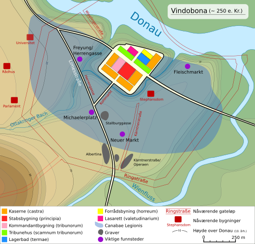
Deutsch: Lageplan von Vindobona (heute:Wien)
Die Höhenlinien geben die Höhe ab Donauspiegel (10.Jh.) an.
English: Map of the area Vindobona (today:Vienna) |
| Date | |
| Source | Own work based on: Vindobona 250-300.svg by Rosso Robot |
| Author | Asav |
| Other versions |
|
| SVG development |


Licensing edit
This file is licensed under the Creative Commons Attribution-Share Alike 3.0 Unported license.
- You are free:
- to share – to copy, distribute and transmit the work
- to remix – to adapt the work
- Under the following conditions:
- attribution – You must give appropriate credit, provide a link to the license, and indicate if changes were made. You may do so in any reasonable manner, but not in any way that suggests the licensor endorses you or your use.
- share alike – If you remix, transform, or build upon the material, you must distribute your contributions under the same or compatible license as the original.
File history
Click on a date/time to view the file as it appeared at that time.
| Date/Time | Thumbnail | Dimensions | User | Comment | |
|---|---|---|---|---|---|
| current | 21:48, 28 March 2016 | | 1,116 × 1,068 (268 KB) | Asav (talk | contribs) | User created page with UploadWizard |
You cannot overwrite this file.
File usage on Commons
The following 5 pages use this file:
File usage on other wikis
The following other wikis use this file: